The Ohio Supreme Court on Thursday dismissed two cases over congressional districts in Ohio.
The decision isn’t a complete surprise because the groups filing the complaints asked for the dismissals earlier this week. But struggles over partisan gerrymandering in Ohio and elsewhere are far from over.
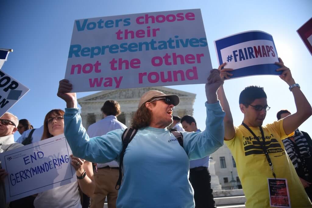
The complainants continue to maintain that Ohio’s congressional districts — as well as its legislative districts — are unfairly gerrymandered. They simply calculate that it’s better to dismiss the cases in light of other developments and because the state Constitution already requires that districts be redrawn after next year’s General Election.
In claiming that Ohio is extremely gerrymandered, the plaintiffs appear to have a point. Former president Donald Trump won the state with less than 54% of the vote in 2020, yet Republicans control 66% of the state’s congressional seats — a 12-point differential.
Many political scientists and other experts say extreme gerrymandering is a problem because by making general elections uncompetitive, it incentivizes candidates to pander to the most extreme elements of their primary electorate. Also, by imposing one-party rule, it creates unaccountable, corrupt majorities, they say.
In May 2018, an amendment to the state Constitution that banned extreme partisan gerrymandering and gave the Ohio Supreme Court the power to throw out maps on that basis passed with an overwhelming 75% of the vote.
Yet the Republican-dominated Redistricting Commission created by the amendment twice ignored rulings by a bipartisan majority on the Ohio Supreme Court rejecting maps it drew in the wake of the 2020 Census. With the clock effectively run out, a panel of three federal judges kept the unconstitutional congressional maps in place for the 2022 election.
Ohio Republicans argued to the U.S. Supreme Court that the state judiciary has almost no power to regulate how legislatures draw congressional districts — no matter what state law says or how gerrymandered those legislatures might already be. That’s known as the “independent legislature doctrine” — which Carolyn Shapiro blasted as “an unprecedented, unconstitutional, and potentially chaos-inducing intrusion into state election law,” in an article this year in the University of Chicago Law Review.
On June 27, six members of U.S. Supreme Court agreed in Moore v Harper. The ruling said the North Carolina Supreme Court had the power to enforce a state law banning excessively partisan congressional maps.
However, gerrymandering foes in Ohio might not find much solace in the decision.
Former state Supreme Court Chief Justice Maureen O’Connor, a Republican, repeatedly joined the court’s three Democrats in ruling that Republican-drawn congressional and legislative maps were excessively partisan. But then she was forced to retire last year because of her age and the new court has a more partisan makeup.
Other recent developments might not hold much hope for Ohio’s anti–gerrymandering groups, either.
The U.S. Supreme Court last October struck down Alabama’s congressional maps in Allen v Milligan. The surprise ruling said that the state’s congressional districts violate the Voting Rights Act by being unduly gerrymandered against Blacks.
It ordered that the state legislature redraw maps so that Alabama Blacks will have a chance at a second seat in the state’s six-seat delegation in which they can select a representative of their choice.
That doesn’t necessarily mean picking a Black representative — or that by merely being Black, a representative meets the requirements of the Voting Rights Act. The law requires that minority communities have a legitimate shot at picking representatives in numbers proportional to their own.
Blacks make up about 27% of Alabama’s population and the ruling in Milligan would give them a chance at power over 33% of its congressional seats, as compared to the current 17% they have power over now.
However, the state’s Republican-dominated legislature twice defied orders to comply with the ruling. On Tuesday, a panel of federal judges rebuked the body and ordered that the new map be independently drawn.
The ruling in Milligan has implications for several other states, such as Louisiana, which have large, underrepresented minority populations.
But Ohio might not be one of them because it doesn’t have the diversity those states do. Whites make up 80% of the state’s population, while Blacks make up just over 13%. The next closest group, Latinos, make up 4.5%.
Louisiana, by contrast, is 63% White, but that group controls 80% of the state’s five congressional districts.
In her role as now-retired chief justice, O’Connor is helping to lead an effort to build even more stringent anti-gerrymandering amendments into the Ohio Constitution. The amendment she’s working to put on the November 2024 ballot would do what the federal panel did to the Alabama legislature on Tuesday — take district drawing out of the hands of partisans and give it to an independent commission.
MARTY SCHLADEN
Marty Schladen has been a reporter for decades, working in Indiana, Texas and other places before returning to his native Ohio to work at The Columbus Dispatch in 2017. He’s won state and national journalism awards for investigations into utility regulation, public corruption, the environment, prescription drug spending and other matters.
For the second time, the Ohio Supreme Court rejected a map for congressional districts in the state.
The court ruled that the map violated the constitution by favoring one political party over another irrespective of election results across the state.
“We hold that the March 2 plan unduly favors the Republican Party and disfavors the Democratic Party in violation of the (Ohio Constitution),” the majority decision reads.
The 4-3 decision reflected the other decisions the court has made on redistricting: Chief Justice Maureen O’Connor voted to reject the maps, along with Justice Michael Donnelly, Justice Melody Stewart and Justice Jennifer Brunner. Justices Sharon Kennedy, Patrick DeWine and Patrick Fischer all dissented in the case.
In ruling against the partisanship in the congressional map, the court called out the commission for creating Democratic districts with razor-thin advantages, while the Republican-leaning seats “comfortably favor Republican candidates.”
In the most recent congressional map, only three Democratic-leaning seats have more than 52% Dem advantage, whereas all Republican-leaning seats have more than 53% GOP advantage.
“Considering that Democratic candidates have received about 47% of the vote in recent statewide elections, this probable outcome represents only a modest improvement over the (previously) invalidated plan,” according to the court decision.
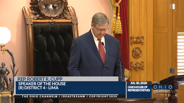
The court pushed back against arguments made by Ohio Redistricting Commission members, including Senate President Matt Huffman and House Speaker Bob Cupp, both of whom have left the commission since then, replaced by state Sen. Rob McColley and state Rep. Jeff LaRe.
The legislative leaders and their replacements on the commission tried to argue they were not obligated to correct “legal defects” in the original congressional plan while revising the plan.
“The commission’s constitutional duty is to adopt a congressional district plan to replace the original, invalidated plan,” the court majority wrote. “Indeed, the commission has a constitutional duty to remedy the defects in the previous plan.”
Huffman, Cupp, McColley and LaRe said fixing the “defects” would “incentivize” Democrats to vote against the plan, and called the article setting forth anti-gerrymandering rules a “safety valve of sorts” for the ORC to adopt a plan that didn’t have to align with the same redistricting rules as the General Assembly.
“No constitutional language suggests that the voters who approved Article XIX intended to allow the prohibitions against partisan favoritism and unduly splitting governmental units to be avoided so easily,” the majority ruled.
The lawsuit was filed in March, after the Ohio Supreme Court turned down calls to reject the maps in a previous lawsuit on congressional redistricting. The court said because its previous decision to reject the first congressional map was final, challengers had to file a new lawsuit to challenge the second version.
The supreme court rejected the first map on the same grounds as the second rejection: partisan favoritism.
In their dissent to the majority decision, Kennedy and Patrick DeWine said they would have left the plan in place as constitutional and allow its use for the 2024 primary and general elections.
Kennedy and DeWine said because they would have held that the first congressional map “did not unduly favor Republicans and was constitutional,” they would have done the same for the second plan.
DeWine, who is Gov. Mike DeWine’s son, has recused himself from any court cases regarding holding the ORC members in contempt of court due to his father’s participation as a commission member. However, he has refused calls for his recusal in all redistricting cases because of his father’s involvement in the process.
Fischer joined the dissent, but wrote separately to argue that map challengers “do not even meet the lower clear-and-convincing evidence burden of proof or the even lower preponderance-of-the-evidence burden of proof” that the second congressional map unduly favored Republicans.
He also criticized the process conducted by the state supreme court, saying a lack of hearings “undoubtedly raises concerns among the public regarding this court’s lack of transparency.”
“This court’s misguided rush to decide these cases has resulted in an unnecessary and truncated procedure that has effectively tied this court’s hands and rendered it unable to make a fully informed decision,” Fischer wrote.
The court gave the General Assembly 30 days to pass a new map, and if they can’t, the Ohio Redistricting Commission will have another 30 days to do so.
Since the May primary, which included congressional races, already occurred, a new congressional plan’s impact will go forward to 2024 elections.
The legislature is currently on summer break, set to come back in the fall. Huffman’s spokesperson did not respond to a request for comment on the ruling, or if they would be reconvening the GA early to deal with the issue.
A spokesperson for Cupp said the office was reviewing the decision.
The ORC’s co-chair, Democratic state Sen. Vernon Sykes joined Senate Minority Leader Kenny Yuko in saying the court “made it clear that Republicans have repeatedly used the redistricting process to give themselves an unfair advantage.”
“Once again, we are ready to follow the law and give Ohioans the fair maps they demanded,” Sykes and Yuko said in a statement. “We hope this time our Republican colleagues will join us, instead of trying to run out the clock.”
A spokesperson Ohio Secretary of State Frank LaRose, the state’s chief elections officer and a member of the redistricting commission, said LaRose’s office had received the ruling and had a legal team reviewing the decision.
The League of Women Voters, one of the two parties who challenged the congressional maps, praised the decision and hoped for swift and public action to adopt new congressional maps.
“We agree that the congressional map is beyond a reasonable doubt gerrymandered, and we stand ready to work with the mapmakers to see a map produced that truly upholds the will of the voters for a free and fair election,” said Jen Miller, executive director of the LWV of Ohio.
Ohio’s House Speaker said Wednesday legislation is not coming to change the May primary date.
Speaker Bob Cupp said the process was “in the hands of the federal court,” despite various court documents in which he argued that the election is a legislative issue and any changes should be made in the General Assembly.
The Ohio Capital Journal asked Cupp directly to confirm the House had no plans for legislation to set a new primary date in the next two weeks.
“That is correct, we’re not in session,” Cupp said during a gaggle after Wednesday’s House session.
He was asked about potential changes to the election earlier in the press gathering, and he deferred the job.
“We’ll let the federal court process proceed,” Cupp said.
A federal lawsuit was filed by GOP voters earlier this year, claiming voters are losing their right to vote with the chaos surrounding redistricting. Originally, the plaintiffs, including Ohio Right to Life leader Michael Gonidakis, asked for the third map adopted by the Ohio Redistricting Commission to be forced into use by a three-judge panel of the U.S. District Court.
That map was rejected by the Ohio Supreme Court before the federal lawsuit was filed, but the process of adopting a fourth version of legislative districts had not come to fruition.
The fourth map ended up being a near-copy of the third, rejected version, with Senate President Matt Huffman acknowledging as he moved for its approval that the map had “97%” similarity to the third version.
Because the process, which started in September, has taken so long, the Secretary of State’s Office was forced to remove legislative races from ballots for the May 3 primary, all but assuring a split primary.
Lawsuits have been filed with the Ohio Supreme Court asking for the fourth map to be invalidated for many of the same reasons the third map was, and map challengers have also asked the court to hold GOP commission members in contempt for violating court orders.
Cupp and Senate President Matt Huffman argued in previous court filings that the power for elections and drawing maps lies solely with the redistricting commission and legislators, seemingly contrary to Cupp’s Wednesday statements.
“It is the commission and the general assembly who solely possess the legislative authority to create legislative and congressional districts,” attorneys for the legislative leaders wrote in a court filing for lawsuits on congressional districts.
Secretary of State Frank LaRose in more recent court filings urged the judicial system to stay out of the process. In his filing countering objections to the most recent maps, he posited that the Ohio Redistricting Commission has more time to figure out legislative maps.
“More importantly, there is still time for the legislature to take steps to extend the time within which such a decision must be made,” LaRose said. “This court should not give up on the constitutional process even if the petitioners have.”
The federal court has chosen twice not to intervene in the state process to give it time to come to a resolution. The first time the court withheld judgment was just before the March 28 deadline for the commission to complete new maps.
At a hearing before Chief Judge Algenon Marbley, Judge Benjamin Beaton and Judge Amul Thapar last Wednesday, parties from the Secretary of State’s Office gave Aug. 2 as a potential date for a second primary to include the legislative races.
The judges entertained the idea of not just the third map, but also the map drawn by independent mapmakers during the latest redistricting commission hearings, and also debated whether or not the 2010 map could be used for one more year.
They decided to give the state until April 20 to come up with an official map and to give the state’s highest court time to make its rulings. A status conference was scheduled for April 11.
House Democrats have thrown their congressional redistricting maps in the ring, completing the partisan caucus proposals.
State Reps. Richard Brown, D-Canal Winchester, and Tavia Galonski, D-Akron, submitted the maps on Friday as what they call “a more realistic vision for Ohio compared to the widely criticized House and Senate Republican maps.”
“Democrats are offering a realistic alternative that addresses issues raised by Ohioans,” Galonski said in a statement. “Our plan is compact, it eliminates the splitting of our largest counties, and reflects the preferences of voters.”
The congressional map proposal released by Ohio House Democrats.
The partisan lean of the map, according to Dave’s Redistricting App analysis, shows a 52.3% Republican lean statewide. It has five competitive districts, with six Republican-leaning districts and four Democratic-leaning districts.
Ohio Republicans have had a 12-4 advantage in congressional districts since the maps were last drawn in 2011, with no congressional seats flipping parties in any election since that time. Ohio lost one district in the 2020 U.S. Census, going from 16 down to 15.
Both the House and Senate GOP maps would incorporate large swaths of Republican territory into Toledo Democratic U.S. Rep. Marcy Kaptur’s district effectively rendering it a Republican district.
The House GOP map splits Hamilton, Franklin, Cuyahoga and Summit counties all into three districts. In Summit, one stretches up to Lake Erie communities such as Ashtabula, and another stretches down to the Hocking Hills area of Southeastern Ohio. In Franklin County, the city of Westerville is moved into the district currently occupied by Republican U.S. Rep. Jim Jordan, and in Hamilton County, Democratic Cincinnati is slimly connected to the entirety of Republican Warren County.
The Senate GOP map also splits Hamilton, Franklin and Cuyahoga counties into three districts, with Democrats holding the advantage in the city centers and Republicans having the advantage in the respective other two districts including parts of each county. This map also moves a significant portion of Franklin County into Jim Jordan’s district. The Senate GOP map also includes most of Montgomery County, home of Dayton, and Republican Warren County in the same district.
A joint committee on congressional redistricting has scheduled hearings for Wednesday and Friday of this week. On Wednesday, the committee will meet at 2:30 p.m. in Room 313 of the Ohio statehouse, and in the same room on Friday at 10:30 a.m.
In committee hearings Wednesday, Republican lawmakers in the House and Senate unveiled their plans for new congressional districts.
In both cases Democrats complained the maps were shared at the eleventh hour, leaving members unable to properly analyze the proposals before them. Procedural votes along partisan lines and unanswered questions about the drafters’ intent seem to presage a bitter fight more likely to produce a lengthy court battle than a 10 year congressional map.
Consequences
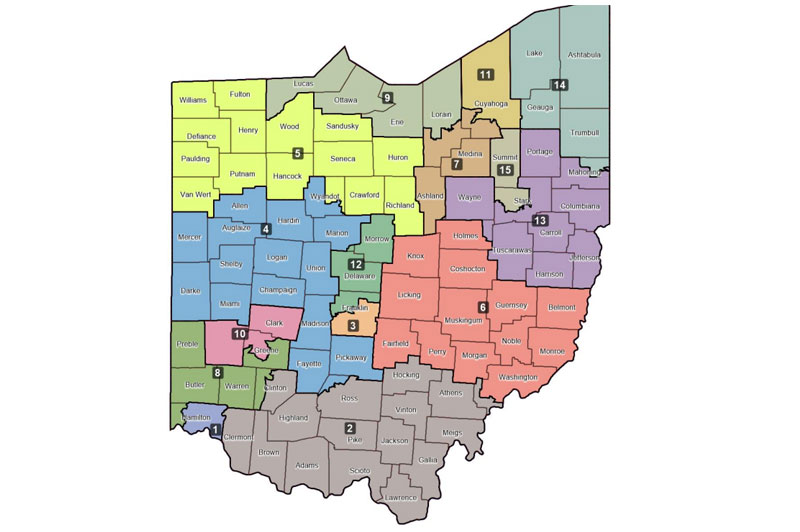
Pictured is Ohio’s congressional delegation as it has looked after the 2012, ’14, ’16, ’18, ’20, and ’21 elections. (Click to view larger map)
Ohio Republicans have had a 12-4 advantage in congressional districts since the maps were last drawn in 2011, with no congressional seats flipping parties in any election since that time. Ohio lost one district in the 2020 U.S. Census, going from 16 down to 15.
Both the House and Senate GOP maps would incorporate large swaths of Republican territory into Toledo Democratic U.S. Rep. Marcy Kaptur’s district effectively rendering it a Republican district. Kaptur said in a statement that fair districts are a foundational requirement of the American Republic, assuring that the voices of all people are able to influence government.
“Lawmakers should not be able to insulate themselves from the views of their constituents through a rigged system of gerrymandering,” she said. “The proposals unveiled today are a clear violation of this most basic principle.”
The House map splits Hamilton, Franklin, Cuyahoga and Summit counties all into three districts. In Summit, one stretches up to Lake Erie communities such as Ashtabula, and another stretches down to the Hocking Hills area of Southeastern Ohio. In Franklin County, the city of Westerville is moved into the district currently occupied by Republican U.S. Rep. Jim Jordan, and in Hamilton County, Democratic Cincinnati is slimly connected to the entirety of Republican Warren County.
The Senate map also splits Hamilton, Franklin and Cuyahoga counties into three districts, with Democrats holding the advantage in the city centers and Republicans having the advantage in the respective other two districts including parts of each county. This map also moves a significant portion of Franklin County into Jim Jordan’s district. The Senate GOP map also includes most of Montgomery County, home of Dayton, and Republican Warren County in the same district.
The House proposal
The guiding principle behind the House map appeared to be plausible deniability. North Canton Republican Scott Oelslager delivered pre-drafted remarks describing how his map complied with new constitutional demands, but he balked at almost every question about his proposal.
The Ohio House Republican proposed U.S. Congressional District map. From the Ohio House of Representatives. (Click to view larger map)
He affably ducked questions from Democratic members as too “technical”, and acknowledged House staffer Blake Springhetti handled the actual drafting of the map. Speaking after the hearing, he admitted even his remarks weren’t all his own — Springhetti helped come up with those, too.
Pressed by Rep. Tavia Galonski, D-Akron, about whether he’d object to Springhetti testifying about the proposal, Oelslager dodged.
“That’s a decision that will be made by leadership above me and counsel,” he said.
Asked more generally by Rep. Richard Brown, D-Canal Winchester, whether his party is even seeking a ten year map, which would require the support of at least a third of Democrats, Oelslager again deflected.
“That’s actually a decision that I’m not involved with; I have not had any discussions with anybody, and I believe that will be a decision made above my pay grade in this process,” Oelslager said.
Every member of the House leadership team, save the speaker, serves on the Government Oversight committee where Oelslager presented his proposal.
Democrats raised objections early, noting the 300 page substitute amendment and Oelslager’s testimony were posted less than 20 minutes before the committee began. Once the documents were shared, the maps were presented in a format that made rapid analysis difficult.
But Democrats did voice concerns about the most obvious potential problems such as the four counties — Hamilton, Franklin, Cuyahoga and Summit — being split among three different districts. Another district runs from Ohio’s southernmost county along the eastern border all the way past Youngstown in the northeast corner of the state.
Despite sidestepping questions on how borders were determined, Oelslager did share a rundown of partisan performance. He described the breakdown as 8-5-2, where Republicans would have eight safe seats, Democrats would have two and five would be a “toss-up.” That toss up range is broad, though, with the majority party having as much as 55% of the likely vote share and the minority having at least 45%.
But outside observers dispute Oelslager’s analysis. The partisan lean metrics in Dave’s Redistricting App suggest the House Proposal would give Republicans a strong advantage in 9 districts, not 8. Four of the remaining districts would be considered competitive based on a 45-55% split, and two would be safe Democratic seats.
Shortly after the committee, Ohio League of Women Voters executive director Jen Miller criticized a lack of transparency in the process. Without maps available ahead of time, she said, it’s impossible to know how good or bad the lines might be.
“We want to think about voters in all 88 counties and how they’re represented and what they need. We can’t do that yet. It’s going to take us quite some time,” Miller explained. “But we certainly are concerned that we could not get the map in a timely fashion, and we are concerned that we are once again maybe running out the clock. Estimates do look as though it is not partisan balanced, which is one of the things I think voters really wanted.”
The Senate proposals
The Senate Local Government and Elections Committee heard about one map that’s been out since the end of September, and another that made its debut during the committee meeting.
State Sen. Rob McColley, R-Napoleon, presents the Senate GOP map in Local Government & Elections Committee on Wednesday. Photo by Susan Tebben, OCJ.
Premiering Wednesday was the Senate GOP’s congressional map, presented by state Sen. Rob McColley, R-Napoleon.
“We wanted to be sure that we put out a map that we were comfortable standing behind and that we felt gave us an opportunity with the minority party to meet and discuss that,” McColley said after presenting his map.
McColley said he was the lead on the map “concepts,” but Ray DiRossi, senate budget director and legislative map-drawer, was the one to insert the concepts into mapping software.
In the Senate Republican map, McColley said 14 counties are split, with the three biggest counties — Cuyahoga, Franklin and Hamilton — split twice.
The Senate GOP map proposal has six Republican-leaning districts, 2 Democrat-leaning and seven that would be competitive, which McColley also defined as being within the 45-55% range.
Statewide election data and constitutionally required data was used in the maps, however McColley said racial data was skipped in the GOP map, something Republicans were criticized for in the legislative map-drawing process.
The Ohio Senate GOP’s proposed U.S. Congressional district map. From the Ohio Senate. (Click to view larger map)
DiRossi told the Ohio Redistricting Commission during his presentation of those maps that racial and demographic data was skipped deliberately at the direction of “legislative leaders.”
Criticism of the maps was limited, mostly because of the abrupt timeline in receiving the GOP map, but an overarching look at the maps gave University of Cincinnati politics professor David Niven a look into political strategy, he said.
“It is an astonishing work of defiance of the constitution, an astonishing defiance of voter will,” Niven said.
Niven said the splitting of counties is at times confusing, which he thinks is a political strategy as part of the maps.
“The effect of this is (voter) confusion and dampened representation,” Niven said.
Collin Marozzi of the ACLU of Ohio said he was still reviewing the Senate effort, but from a brief look during the committee meeting, it didn’t surprise him to see Republicans making the decisions they made, but he wanted to hear more about why.
“It’s deliberate choices, they made their choices and I think the people of Ohio deserve to have an explanation as to why they made them, not just the fact that they did or didn’t make them,” Marozzi said.
State Senate Minority Leader Kenny Yuko and state Sen. Vernon Sykes presented the Senate Democratic Caucus map officially to the commission, with policy advisor Randall Routt jumping in with breakdowns directly from the map.
“As elected leaders, we owe it to our constituents to produce fair maps,” Yuko said. “Let’s work together, and let’s get this mission accomplished.”
The Democratic map came just before the Oct. 1 deadline for the legislature to approve congressional redistricting maps the first time, which blew by without any significant action from either General Assembly body.
The deadline passed, and the process moved to the Ohio Redistricting Commission, on which Sykes sat as co-chair, and their Oct. 31 deadline came and went without any map approval.
In Wednesday’s committee meeting, Routt said the map was “merely a starting proposal” but a proposal they felt complied with not only the Ohio constitution, but the salvaging of communities across Ohio.
The Ohio Senate Dems proposed congressional district map. (Click to view larger map)
In explaining the map, Routt said only 11 counties were split, with the splits only occurring once in each county. No counties were split more than once.
“We attempt to keep communities together in our map, and we think that’s an overriding state objective,” Routt told the committee.
Committee member state Sen. Tina Maharath, D-Canal Winchester, took time to ask if Democratic bill sponsors felt the redistricting process had met expectations. Yuko and Sykes both said no, and Sykes said with no GOP map to consider until Wednesday, it’s been difficult to negotiate a ten-year plan with bipartisan agreement.
“We’re at this third stage of this process and fortunately it looks like today … we’re starting out hopefully with a plan, and maybe we’ll be better able to negotiate a bipartisan deal,” Sykes said.
McColley said concerns about transparency are not necessarily well-placed, and likened the process to creating a piece of legislation, in that some preparatory conversations “don’t happen in the public.”
“Usually there’s a public proposal … and then we’ll have a proposal and a process going forward to work off of, and that’ll inform much of the public dialogue that occurs with this map,” McColley said.
All three maps are the subject of scheduled public hearings Thursday morning in Senate Local Government and Elections and House Government Oversight.


