
by David Miller
Loveland, Ohio – The National Weather Service in Wilmington says, “Expect numerous showers and a few rumbles of thunder throughout this afternoon.”
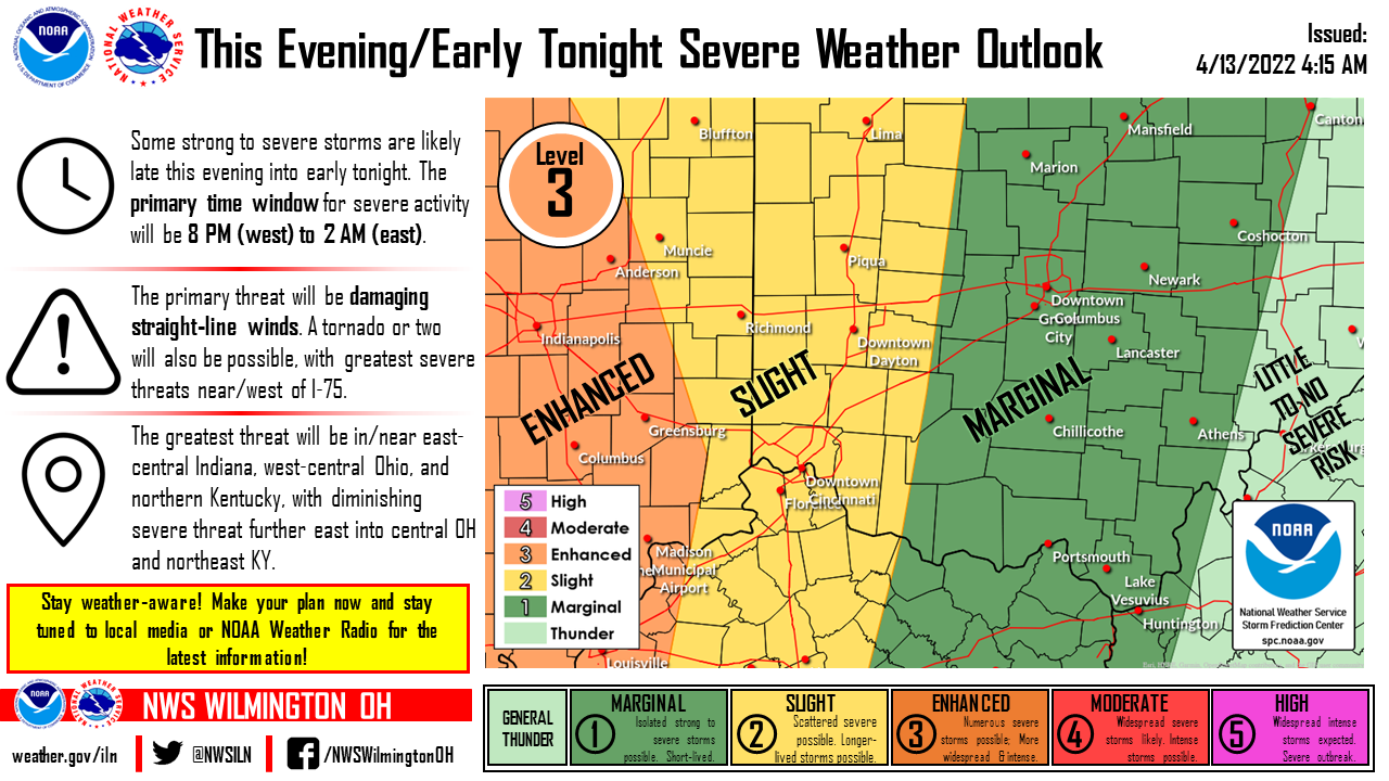
Main focus/message: a line of storms is expected to move into the local area late this evening.
Main threat remains strong/damaging winds. Severe threat diminishes further east.
Severe Weather Threat: Are you Ready?
As temperatures warm, many Midwesterners face a heightened risk of severe storms. Monitor local forecasts, and take steps now to prepare for the possibility of a dangerous situation.
“The threat of severe weather should be taken seriously,” said FEMA Region 5 Administrator Thomas Sivak. “Now is the time to make sure you and those you care about know where to go to stay safe in case those risks become reality.”
- Follow the direction of local and state officials and make sure to sign up for your community’s warning system. The Emergency Alert System (EAS) and National Oceanic and Atmospheric Administration (NOAA) Weather Radio also provide emergency alerts. If your community has sirens, become familiar with the warning tone.
- Identify nearby, sturdy buildings close to where you live, work, study and play. Pay attention to weather reports and warnings and be ready to take shelter immediately, if necessary.
- Secure your property. Remove any dead trees or overhanging branches near structures, loose roofing materials and objects in yards, patios, roofs or balconies that could blow away.
- Make sure all mobile devices are fully charged in advance of the storm. Plan for batteries and other alternative power sources to meet your needs in case the power goes out, such as a portable charger or power bank. Have flashlights for every household member.
- Watch for fallen power lines and trees. Report them immediately.
- After the storm and once you are safe, check on neighbors and friends to make sure they’re okay.
Find even more valuable tips to help you prepare for severe weather at www.ready.gov/severe-weather and download the free FEMA app, available for your Android, Apple or Blackberry device.
Types of Weather Alerts
Watches, Warnings and Alerts
Severe Weather Alerts
A thunderstorm is considered severe if it produces hail at least 1 inch in diameter or has wind gusts of at least 58 miles per hour (50 knots). Every thunderstorm produces lightning, which kills more people, some years, than tornadoes or hurricanes. Heavy rain from thunderstorms can cause flash flooding. High winds can damage homes and blow down trees and utility poles, causing widespread power outages. Every year people are killed or seriously injured because they didn’t hear or chose to ignore severe thunderstorms warnings.
- Listen to the local news or a NOAA Weather Radio for emergency updates. Watch for signs of a storm- darkening skies, lightning flashes, or increasing wind.
- If you can hear thunder, you are close enough to be in danger from lightning. If thunder roars, go indoors! Don’t wait for rain. Lightning can strike out of a clear blue sky.
- Avoid electrical equipment and corded telephones. Cordless phones, cell phones and other wireless handheld devices are safe to use.
- Keep away from windows.
- If you are driving, try to safely exit the roadway and park. Stay in the vehicle and turn on the emergency flashers until the heavy rain ends.
- If you are outside and cannot reach a safe building- avoid high ground, water, tall, isolated trees, and metal objects (fences, bleachers). Picnic shelters, dugouts, and sheds are NOT safe.
More information can be found here – Lighting Safety
Watches vs. Warnings

- Severe Thunderstorm Watch: Be Prepared! Severe thunderstorms are possible in and near the watch area. Stay informed and be ready to act if a severe thunderstorm warning is issued. The watch area is typically large- covering numerous counties or even states. (Watches are issued by the Storm Prediction Center of the NWS for counties where severe thunderstorms may occur.)
- Severe Thunderstorm Warning: Take Action! Severe weather has been reported by spotters or indicated by radar. Warnings indicate imminent danger to life and property. Take shelter in a substantial building. Get out of mobile homes that can blow over in high winds. Warnings typically encompass a much smaller area (around the size of a city or small county) that may be impacted by a large hail or damaging wind identified by a NWS forecaster on radar or by a trained spotter/public official who is watching the storm. (Warnings are issued by your local NWS forecast office.
More information can be found here – Severe Thunderstorm
- Tornado Watch: Be Prepared! A Tornado Watch means that tornadoes are possible in and near the watch area. Review and discuss your emergency plans and check supplies and your safe room. Be ready to act quickly if a warning is issued or you suspect a tornado is approaching. Acting early helps to save lives! Watches are issued by the Storm Prediction Center for counties where tornadoes may occur. The watch area is typically large, covering numerous counties or even states
- Tornado Warning: Take Action! A tornado has been sighted or indicated by weather radar. There is imminent danger to life and property. Move to an interior room on the lowest floor of a sturdy building. Avoid windows. If in a mobile home, a vehicle, or outdoors, move to the closest substantial shelter and protect yourself from flying debris. Warnings are issued by your local forecast office. Warnings typically encompass a much smaller area (around the size of a city or small county) that may be impacted by a tornado identified by a forecaster on Radar or by a trained spotter/law enforcement who is watching the storm.
More information can be found here – Tornado Safety
- Flash Flood Warning: Take Action! A Flash Flood Warning is issued when a flash flood is imminent or occurring. If you are in a flood prone area move immediately to high ground. A flash flood is a sudden violent flood that can take from minutes to hours to develop. It is even possible to experience a flash flood in areas not immediately receiving rain.
- Flood Watch: Be Prepared! A Flood Watch is issued when conditions are favorable for a specific hazardous weather event to occur. A Flood Watch is issued when conditions are favorable for flooding. It does not mean flooding will occur, but it is possible.
- Flood Warning: Take Action! A Flood Warning is issued when the hazardous weather event is imminent or already happening. A Flood Warning is issued when flooding is imminent or occurring.
More information can be found here – Flood Safety
Outdoor Warning Siren System
What is the Purpose of the Sirens?

Hamilton County’s Outdoor Warning Siren System consists of approximately 190 strategically-placed sirens. These sirens serve as an early warning device to alert citizens to take shelter indoors and seek additional information. While the outdoor warning system can be an effective method of notifying those that are outdoors, to seek shelter indoors, it is only one component of a comprehensive emergency warning system. In addition, you should obtain a NOAA weather radio and tune in to local media reports from television, radio, or social media.
Designed as an Outdoor Warning System, the sirens SHOULD NOT be relied upon to provide sufficient warning INDOORS or in NOISY AREAS. Additionally, air conditioning, thunder, wind, rain, and other conditions can cause the sirens not to be heard indoors or outdoors, even if sirens can be heard during monthly tests. Sirens are also subject to lightning strikes and other equipment malfunction. Because the sirens are constantly exposed to the elements and other hazards, Hamilton County EMHSA cannot guarantee that the sirens will function correctly. For these reasons, everyone is encouraged to have multiple ways to receive information about severe weather.
Activation Criteria
There are three basic criteria that Hamilton County EMHSA uses to activate the sirens:
- The National Weather Service (NWS) issues a Tornado Warning for Hamilton County.
- A tornado is reported by a local public safety official (police/firefighter) to the NWS or to Hamilton County EMHSA.
- A dangerous situation occurs which requires the public to seek shelter indoors immediately.
Hamilton County has the capability of activating all of the sirens at once or by activating one or more of six siren zones. All sirens are sounded unless the threat is clearly confined to an individual zone (or zones). During a tornado warning, the sirens will be sounded for a three minute duration in ten minute intervals (three minutes on, seven minutes off) for as long as the tornado warning is in effect. There is NO “all-clear” siren.
Siren Test Cancellation Criteria
Basic criteria for cancelling the activation of the Outdoor Warning Sirens include:
- Extreme cold, freezing rain/drizzle, and/or icing that may damage the equipment.
- Presence of severe weather (or potential severe weather) occurring in the local area, which may cause confusion as to whether the activation is a real event.
Monthly Testing:
The Outdoor Warning Siren System will be tested on the first Wednesday of each month at 12:00 p.m., unless there is inclement weather in Hamilton County. A siren test will consist of a single siren tone, lasting approximately 1 minute. Hamilton County EMHSA will notify the public via press release and social media posts when a siren test is planned, cancelled, or rescheduled, prior to the time at which the sirens will sound.
If Hamilton County is experiencing severe weather prior to 12:00 p.m. on a scheduled test day, the siren test may be postponed, to the determined alternate test day, which is the second Wednesday of the month, at 12 p.m. Testing for the alternate day will consist of a “Growl” test. A “growl” test is a quick sounding of the sirens, lasting approximately six seconds, which tests the activation and rotation of each siren. If testing the sirens on the alternate day is also canceled, the Outdoor Warning Siren tests will resume on the next scheduled monthly date.
Siren testing may be suspended during the winter months (December – February) when ice or sub-freezing temperatures could damage the siren system. If there is an emergency during winter months, the sirens will be activated to notify people of the need to seek shelter.
If testing is required at any time outside of the normal monthly testing schedule, Hamilton County Emergency Management and Homeland Security Agency will be sure to notify the public via social media posts and press release.
Siren Maintenance
Hamilton County EMHSA maintains approximately 190 sirens throughout the county. Each siren is inspected at least every three years. The maintenance/inspection program as adopted by Hamilton County EMHSA consists of checking the operations of the siren, battery strength, terminal connections, site conditions, obstructions that may interfere with the siren. During maintenance and inspection, the siren is “growled.” This short activation may occur several times during our inspection. If you have questions regarding a siren being sounded in your neighborhood, please feel free to contact Hamilton County EMHSA. The siren contractor hired by Hamilton County EMHSA to conduct maintenance on the sirens, is documented and will be carrying identifying information.
Outdoor Warning Siren System Informational Brochure

ALERT HC—MASS NOTIFICATION AND WARNING SYSTEM
Alert Hamilton County (Alert HC) and Smart911 are a joined effort to both notify residents, visitors, and those who work in Hamilton County of emergency situations and other important information, as well as provide an opportunity to create a Safety Profile that can save vital response time during an emergency. With Alert HC, users are able to choose from more than 42 different alerts they may wish to be notified about to keep themselves and their families safe. This system is completely customizable and allows users to choose which alerts they want to receive and how they want to receive them. Alert Hamilton County can notify users via text message, and email, with phone call notification available for the following alerts: Civil Emergency Message, Civil Danger Warning, Evacuation Immediate, Shelter In Place, Tornado Warning, Flash Flood Warning, Flood Warning, and Municipal Alerts.

SMART911
Alert Hamilton County is paired with a system called “Smart911,” which allows your important information to be shared with 9-1-1 call takers and first responders during an emergency. With Smart911, both 9-1-1 call takers and first responders can know exactly what you want them to know during any kind of emergency. You can add vital information, such as information about members of your household, medical details, disabilities and equipment, address and property details, as well as emergency contact information and communication preferences.
Download the NEW Smart911 App available in the App Store and Google Play. For a quick and easy sign up, text “SMART911” to 67283!