Tag: Kings Mills

  • Little Miami expected to reach “Minor Flooding” stage

    Little Miami expected to reach “Minor Flooding” stage

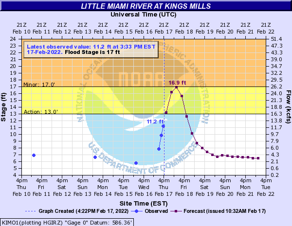
    The graph above is from the National Weather Service depicting potential river levels around the Kings Mills area.

    The National Weather Service predicts that today’s rain will cause the Little Miami River to reach “Minor Flooding” levels tonight.

    At the Kings Mills monitoring location it is predicted there will be flooding of lowland areas occurring from South Lebanon to Foster. Portions of Mason-Morrow-Millgrove Road will also flood, as well as Stubbs Mills Road near the river, including Front Street in Morrow floods.

    Lowland flooding is possible along the Little Miami River in Clermont and Hamilton Counties, with flooding of Karl Brown Way near Loveland.

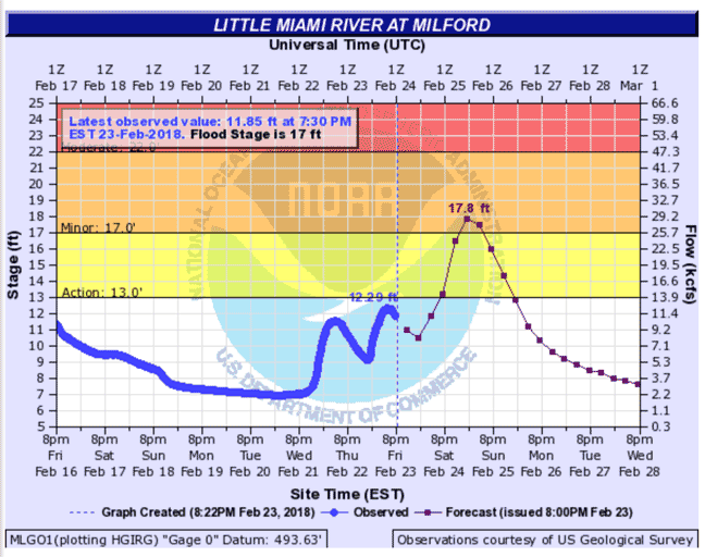
    The river is expected to crest near 17′ at Kings Mills and 16.5′ in Milford.

    FLOOD WATCH IN EFFECT UNTIL 1 AM EST FRIDAY...
    
    This Hazardous Weather Outlook is for East Central Indiana,
    Southeast Indiana, Central Ohio, Southwest Ohio and West Central
    Ohio.
    
    .DAY ONE...Tonight.
    
    Please listen to NOAA Weather Radio or go to weather.gov on the
    Internet for more information about the following hazards.
    
       Flood Watch.
    
    A rapid freeze-up is possible tonight as temperatures drop quickly
    below freezing.
    
    .DAYS TWO THROUGH SEVEN...Friday through Wednesday.
    
    Lingering high water may cause flooding to persist Friday and into
    this weekend, even after the heavy rain ends.
    Weather Forecast
    This Afternoon
    Rain and possibly a thunderstorm. Some of the storms could produce heavy rainfall. High near 60. South wind around 13 mph, with gusts as high as 29 mph. Chance of precipitation is 100%. New rainfall amounts between a quarter and half of an inch possible.
    Tonight
    Rain and thunderstorms likely before 11pm, then a slight chance of rain between 11pm and midnight. Some of the storms could produce heavy rain. Cloudy, with a low around 23. West wind 10 to 18 mph becoming north in the evening. Winds could gust as high as 29 mph. Chance of precipitation is 70%. New precipitation amounts between a quarter and half of an inch possible.
    Friday
    Mostly cloudy through mid morning, then gradual clearing, with a high near 35. Northwest wind 6 to 9 mph becoming southwest in the afternoon.
    Friday Night
    Mostly clear, with a low around 24. Southwest wind 6 to 11 mph.
  • Joseph M. Timmerman’s long-exposure photo from the Peters Cartridge factory

    Joseph M. Timmerman’s long-exposure photo from the Peters Cartridge factory

    Joseph M. Timmerman is a resident of Historic Downtown Loveland and attends Loveland High School. He took this photo at the the Peters Cartridge factory.

    The Peters Cartridge Company was a company in Kings Mills, Ohio that specialized in gunpowder and ammunition production. Its historic buildings, built in 1916 at 1415 Grandin Road, were added to the National Register of Historic Places on October 10, 1985. Wikipedia


  • Little Miami above flood stage in Milford and Kings Mills Friday evening

    Little Miami above flood stage in Milford and Kings Mills Friday evening

    The Little Miami River went above flood stage in Milford at 7:30 PM Friday evening. The National Weather Service reported the river at 17.8 feet. Flood level is 17 feet. The level is virtually the same at the Kings Mills recording station. There is no measuring gague in Loveland.

    Detailed Weather Forecast for Loveland from the National Weather Service

    Tonight
    Showers likely, mainly after 4am. Cloudy, with a low around 47. West wind around 6 mph becoming north after midnight. Chance of precipitation is 60%. New precipitation amounts between a tenth and quarter of an inch possible.
    Saturday
    Showers, with thunderstorms also possible after 5pm. High near 55. East wind around 8 mph. Chance of precipitation is 90%. New rainfall amounts between a half and three quarters of an inch possible.
    Saturday Night
    Showers and possibly a thunderstorm. Low around 52. Breezy, with a southeast wind 8 to 13 mph becoming southwest 15 to 20 mph after midnight. Winds could gust as high as 32 mph. Chance of precipitation is 100%. New rainfall amounts between 1 and 2 inches possible.
    Sunday
    A chance of showers before 7am. Mostly sunny, with a high near 54. West wind 11 to 16 mph, with gusts as high as 26 mph. Chance of precipitation is 30%. New precipitation amounts of less than a tenth of an inch possible.
    Sunday Night
    Partly cloudy, with a low around 33. West wind 5 to 7 mph becoming calm in the evening.
    Monday
    Sunny, with a high near 56.
    Monday Night
    Mostly clear, with a low around 32.
    Tuesday
    Sunny, with a high near 60.
    Tuesday Night
    Mostly cloudy, with a low around 43.
    Wednesday
    A chance of showers after 7am. Mostly cloudy, with a high near 59. Chance of precipitation is 50%.
    Wednesday Night
    Showers likely. Mostly cloudy, with a low around 47. Chance of precipitation is 60%.
    Thursday
    Showers likely. Mostly cloudy, with a high near 58. Chance of precipitation is 60%.
    Thursday Night
    A chance of showers. Mostly cloudy, with a low around 39. Chance of precipitation is 30%.
    Friday
    Partly sunny, with a high near 47.