Tag: National Weather Service

  • Latest “Winter Storm Warning” for Loveland from National Weather Service

    Latest “Winter Storm Warning” for Loveland from National Weather Service

    Loveland, Ohio

    Today
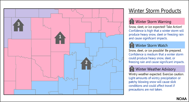
    Snow, mainly after 10am. High near 27. Calm wind becoming east 5 to 7 mph in the afternoon. Chance of precipitation is 90%. Total daytime snow accumulation of 1 to 3 inches possible.
    Tonight
    Snow and sleet before 2am, then snow, freezing rain, and sleet. The snow and sleet could be heavy at times. Low around 21. East wind 9 to 16 mph, with gusts as high as 29 mph. Chance of precipitation is 100%. Little or no ice accumulation expected. New snow and sleet accumulation of 3 to 7 inches possible.
    Monday
    Snow, possibly mixed with freezing rain, becoming all snow after 10am. High near 29. North wind 15 to 17 mph, with gusts as high as 30 mph. Chance of precipitation is 100%. Little or no ice accumulation expected. New snow accumulation of 1 to 3 inches possible.
    Monday Night
    A chance of snow and freezing rain before 8pm. Cloudy, then gradually becoming partly cloudy, with a low around 10. Northwest wind 5 to 11 mph. Chance of precipitation is 30%. New snow accumulation of less than a half inch possible.
    Tuesday
    Mostly sunny, with a high near 27. Northwest wind 3 to 7 mph.
    Tuesday Night
    Mostly cloudy, with a low around 9.
    Wednesday
    Partly sunny, with a high near 23.
    Wednesday Night
    Mostly cloudy, with a low around 4.
    Thursday
    Sunny, with a high near 22.
    Thursday Night
    Partly cloudy, with a low around 7.
    Friday
    A chance of snow. Partly sunny, with a high near 28. Chance of precipitation is 30%.
    Friday Night
    A chance of snow. Mostly cloudy, with a low around 17. Chance of precipitation is 50%.
    Saturday
    Partly sunny, with a high near 30.
  • Do you know the Winter weather alerts?

    Do you know the Winter weather alerts?

    Loveland, Ohio – Below are the definitions of winter weather “Watch”, “Warnings”, and “Advisories” issued by the National Weather Service and our local forecast.

    Today
    Showers, mainly before 2pm. High near 53. Breezy, with a west wind 10 to 20 mph, with gusts as high as 34 mph. Chance of precipitation is 100%. New precipitation amounts of less than a tenth of an inch possible.
    Tonight
    A chance of snow showers, mainly after 3am. Increasing clouds, with a low around 31. West wind 13 to 17 mph. Chance of precipitation is 40%. New snow accumulation of less than a half inch possible.
    Thursday
    Snow showers, mainly before 1pm. High near 36. Breezy, with a west wind 18 to 22 mph, with gusts as high as 32 mph. Chance of precipitation is 80%. New snow accumulation of less than one inch possible.
    Thursday Night
    Snow showers. Low around 28. Southwest wind 11 to 18 mph becoming northwest after midnight. Chance of precipitation is 90%. New snow accumulation of 1 to 2 inches possible.
    Friday
    A chance of snow showers before 11am, then a chance of rain and snow showers between 11am and 1pm, then a chance of rain showers after 1pm. Mostly cloudy, with a high near 43. West wind 11 to 17 mph, with gusts as high as 28 mph. Chance of precipitation is 50%. New snow accumulation of less than a half inch possible.

    Hazardous Weather Outlook
    National Weather Service Wilmington OH
    848 AM EST Wed Nov 20 2024
    Wayne-Fayette-Union-Franklin-Ripley-Dearborn-Ohio-Switzerland-
    Carroll-Gallatin-Boone-Kenton-Campbell-Owen-Grant-Pendleton-Bracken-
    Robertson-Mason-Lewis-Hardin-Mercer-Auglaize-Darke-Shelby-Logan-
    Delaware-Miami-Champaign-Clark-Madison-Licking-Preble-Montgomery-
    Greene-Pickaway-Fairfield-Butler-Warren-Clinton-Ross-Hocking-
    Hamilton-Clermont-Brown-Highland-Adams-Pike-Scioto-
    848 AM EST Wed Nov 20 2024

    This Hazardous Weather Outlook is for east central Indiana,
    southeast Indiana, northeast Kentucky, northern Kentucky, central
    Ohio, south central Ohio, southwest Ohio and west central Ohio.

    DAY ONE…Today and tonight

    Wind gusts up to 40 mph will be possible this afternoon. Snow
    showers will move into the region overnight tonight bringing some
    minor snow accumulations, mainly on elevated and grassy surfaces.

    DAYS TWO THROUGH SEVEN…Thursday through Tuesday

    Snow showers are expected Thursday morning and then again Thursday
    night. Snowfall accumulations will be possible, especially on
    elevated and grassy surfaces.

    Winter weather related Warnings, Watches and Advisories are issued by your local National Weather Service office. Each office knows the local area and will issue Warnings, Watches or Advisories based on local criteria. For example, the amount of snow that triggers a “Winter Storm Warning” in the Northern Plains is typically much higher than the amount needed to trigger a “Winter Storm Warning” in the Southeast.

    +Warnings: Take Action!

    +Watches: Be Prepared

    +Advisories: Be Aware

    Here are some more key terms to understand:

    • Freezing Rain: Rain that freezes when it hits the ground; creating a coating of ice on roads, walkways, trees and power lines.
    • Sleet: Rain that turns to ice pellets before reaching the ground. Sleet also causes moisture on roads to freeze and become slippery.
    • Wind Chill: A measure of how cold people feel due to the combined effect of wind and cold temperatures; the Wind Chill Index is based on the rate of heat loss from exposed skin. Both cold temperatures and wind remove heat from the body; as the wind speed increases during cold conditions, a body loses heat more quickly. Eventually, the internal body temperature also falls and hypothermia can develop. Animals also feel the effects of wind chill; but inanimate objects, such as vehicles and buildings, do not. They will only cool to the actual air temperature, although much faster during windy conditions.

    Find the current forecast at weather.gov.

  • Winter Weather Advisory

    Winter Weather Advisory

    Loveland, Ohio – The National Weather Service in Wilmington has issued this Winter Weather Advisory in effect from January 16, 12:00 PM EST until January 17, 07:00 AM EST.

    URGENT - WINTER WEATHER MESSAGE
    National Weather Service Wilmington OH
    959 AM EST Sun Jan 16 2022
    
    KYZ096-OHZ072-078-162300-
    /O.CON.KILN.WW.Y.0003.220116T1700Z-220117T1200Z/
    Pendleton-Clinton-Clermont-
    Including the cities of Falmouth, Butler, Wilmington,
    Blanchester, and Milford
    959 AM EST Sun Jan 16 2022
    
    ...WINTER WEATHER ADVISORY REMAINS IN EFFECT UNTIL 7 AM EST
    MONDAY...
    
    * WHAT...Snow expected. Total snow accumulations of 1 to 2
      inches. Some brief mixing with sleet or rain is also possible.
    
    * WHERE...In Ohio, Clinton and Clermont Counties. In Kentucky,
      Pendleton County.
    
    * WHEN...From noon today to 7 AM EST Monday.
    
    * IMPACTS...Plan on slippery road conditions. The hazardous
      conditions could impact the morning commute.
    
    PRECAUTIONARY/PREPAREDNESS ACTIONS...
    
    Slow down and use caution while traveling.
    
    Additional information can be found at www.weather.gov/iln as
    well as on our Facebook and Twitter pages.
  • Become a Skywarn Weather Spotter for the National Weather Service

    Become a Skywarn Weather Spotter for the National Weather Service

    Loveland, Ohio – Here’s a great opportunity for public service for individuals with interests in weather and communication: Take a 2-hour virtual class led by a National Weather Service meteorologist to become a Skywarn Weather Spotter. 

    Skywarn spotters volunteer to become the “eyes and ears” of the National Weather Service. Spotters serve their community by acting as a valuable source of information when dangerous storms approach.

    Classes are free, open to the public, and require registration via the links provided in each course description below. Each class covers techniques and safety for severe weather spotting. Once you attend a class, you will receive instructions for filling out online registration forms to officially become a trained spotter and can report severe weather to your NWS office. 

    During the webinar, a National Weather Service meteorologist will teach you how to properly identify and report significant weather events that have an impact on the safety of your community, such as damaging winds, hail, heavy rain, and tornadoes. At this time, there are no in-person spotter training courses scheduled for the 2021 spring season. 

    The National Weather Service encourages anyone with an interest in public service and access to communication, such as amateur radio, to participate as a Skywarn storm spotter. Volunteers include police and fire personnel, dispatchers, EMS workers, public utility workers, and other concerned private citizens. Individuals affiliated with hospitals, schools, churches, nursing homes, or who have a responsibility for protecting others are also encouraged to become a spotter. 

    Spotter Webinar 1: Friday, February 19, 2021 (1 PM – 3 PM): https://register.gotowebinar.com/register/8258577384418148110

    Spotter Webinar 2: Wednesday, February 24, 2021 (7 PM – 9 PM): https://register.gotowebinar.com/register/4105945167168648206

    Spotter Webinar 3: Thursday, March 4, 2021 (7 PM – 9 PM): https://register.gotowebinar.com/register/8790359481726954766

    Spotter Webinar 4: Monday, March 8, 2021 (6 PM – 8 PM): https://register.gotowebinar.com/register/5017422714408992270

    Spotter Webinar 5: Tuesday, March 23, 2021 (6 PM – 8 PM): https://register.gotowebinar.com/register/8257513057162542350

    Spotter Webinar 6: Saturday, March 27, 2021 (12 PM – 2 PM): https://register.gotowebinar.com/register/5687758669980329230

    This information and registration links are also available at the spotter training website — https://www.weather.gov/iln/spotter training schedule.

  • Just for the Record: The snow from Nov. 11 – 12 was indeed deeply early

    Just for the Record: The snow from Nov. 11 – 12 was indeed deeply early

    Loveland, Ohio – From the records of the National Weather Service.

    “The first widespread snowfall of the season affected the region on Veterans Day into November 12th.”

    SNOWFALL AT THE CINCINNATI NORTHERN KENTUCKY AIRPORT WAS 2.3 INCHES ON NOVEMBER 12. THIS BREAKS THE OLD RECORD FOR SNOWFALL IN CINCINNATI ON NOVEMBER 11 WHICH WAS 1.3 INCHES IN 1894.

    2.4″ in Mainville

    2.5″ in Goshen

    3″ in Sharonville

    3.5″ in Wilmington


    Cincinnati (data back to 1893)

    Earliest date of measurable snowfall October 19, 1989
    (5.0 inches)
    Latest seasonal first measurable snowfall January 12, 1983
    (0.1 inches)
    Earliest date of 1 inch or more of snowfall October 19, 1989
    (5.0 inches)
    Most snowfall on any day in October 5.9 inches
    (October 30, 1993)
    Most snowfall on October 31st 0.3 inches (1993)
    Number of times measurable snow has fallen on October 31st Once (1993)
    Average date of first measurable snowfall (1981-2010) November 29
    Average date of first 1 inch or more of snowfall (1981-2010) December 15

    Note that the term “measurable” denotes snowfall that is equal to or greater than a tenth of an inch. Continuous records of snowfall data in autumn go back to 1893 for Cincinnati, 1885 for Columbus, and 1910 for Dayton.


  • E. Kemper closed due to rising water

    E. Kemper closed due to rising water

    Loveland, Ohio – East Kemper Road near the 10098 block (Northeast of Victor Avenue) is currently closed to traffic because of rising waters from the Little Miami River.

    Karl Brown Way and E. Broadway in Historic Downtown are currently open, however will certainly close because of the rapidly rising water.

    The National Weather Service in Wilmington has issued a “Flood Warning” that is in effect from April 3, 1:47 PM EDT until April 4, 4:15 PM EDT.

    Today
    Showers and thunderstorms likely, mainly after 5pm. Some of the storms could be severe. Cloudy, with a high near 71. South wind 13 to 18 mph, with gusts as high as 34 mph. Chance of precipitation is 70%. New rainfall amounts between a quarter and half of an inch possible.
     
    Tonight
    Showers and thunderstorms before 1am, then a chance of showers. Some of the storms could be severe. Low around 38. Breezy, with a south wind 17 to 20 mph becoming west after midnight. Winds could gust as high as 32 mph. Chance of precipitation is 90%. New rainfall amounts between a half and three quarters of an inch possible.
     
    The Little Miami is expected to reach near “Moderate Flood Stage” at midnight and to reach “Flood Stage” at Kings Mills.
     

    Hazardous Weather Outlook

    Hazardous Weather Outlook
    National Weather Service Wilmington OH
    1031 AM EDT Tue Apr 3 2018
    
    INZ073>075-080-KYZ089>100-OHZ077>082-088-041445-
    Ripley-Dearborn-Ohio-Switzerland-Carroll-Gallatin-Boone-Kenton-
    Campbell-Owen-Grant-Pendleton-Bracken-Robertson-Mason-Lewis-Hamilton-
    Clermont-Brown-Highland-Adams-Pike-Scioto-
    1031 AM EDT Tue Apr 3 2018
    
    This Hazardous Weather Outlook is for Southeast Indiana, Northeast
    Kentucky, Northern Kentucky, South Central Ohio and Southwest Ohio.
    
    .DAY ONE...Today and Tonight.
    
    Wind gusts to 35 MPH will be possible this afternoon and evening.
    
    Thunderstorms will develop this afternoon and evening, and some
    severe storms are expected. These storms will be capable of producing
    damaging wind, large hail, tornadoes, and heavy rainfall. The most
    likely timing for severe weather will be between 5PM and 2AM.
    
    .DAYS TWO THROUGH SEVEN...Wednesday through Monday.
    
    Wind gusts of 30-35 MPH will be possible early Wednesday morning.
  • Why did you receive the false Flood Warning Alert Thursday night?

    Why did you receive the false Flood Warning Alert Thursday night?

    Loveland, Ohio – On Thursday, March 29 at 11:20 PM, many residents received a phone call from the Hamilton County Emergency Management & Homeland Security Agency. It was a recorded robocall notifying residents that a flood warning had been issued. Problem was, it was supposed to alert residents along the Great Miami River, not the Little Miami. The failure was due to a malfunction in Hamilton County’s mass notification tool according to Ryan McEwan, the Assistant Director of the agency. The National Weather Service in Wilmington issued a Flood Warning for the Great Miami River in western Hamilton County.

    In a press release, McEwan said, “Hamilton County Emergency Management & Homeland Security Agency (EMHSA) is working with our mass notification vendor to identify why the malfunction occurred and to ensure it does not occur again.”

    On the agency’s Facebook page one resident posed this question:

    “I got a call at 11:30 on my land line phone. I didn’t subscribe. Wondering why.”

    The agency responded:

    “You were alerted of the Flood Warning because our system is set up to call land lines during an emergency that could threaten life safety or when severe weather (like a Tornado Warning or Flood Warning) is issued for your area. Unfortunately, there was a malfunction in the system last night that called more residents than intended. We have since fixed this issue and it should not happen again. We sincerely apologize for the inconvenience.”

    Another resident asked this question:

    “The phone call at that hour of the night scared me half to death!! I was afraid there was something wrong with one of our children or grandchildren!”

    The agency did not respond.

    Another resident asked this question:

    “When it IS working properly, will we be notified every hour on the hour? That how it worked for me overnight…1x would have been sufficient. Just wondering, thank you!”
     
    The agency responded:
     
    “No ma’am. I really apologize for the inconvenience. We have addressed the issue so that the system will work as intended. Again, we sincerely apologize.”


    RP Diamond Printing & Embroidery

      RP Diamond is the exclusive retailer of LOVELAND HIGH SCHOOL SPIRIT WEAR Welcome to  RP Diamond Printing & Embroidery located at 370 Loveland Madeira Road.


  • Little Miami above flood stage in Milford and Kings Mills Friday evening

    Little Miami above flood stage in Milford and Kings Mills Friday evening

    The Little Miami River went above flood stage in Milford at 7:30 PM Friday evening. The National Weather Service reported the river at 17.8 feet. Flood level is 17 feet. The level is virtually the same at the Kings Mills recording station. There is no measuring gague in Loveland.

    Detailed Weather Forecast for Loveland from the National Weather Service

    Tonight
    Showers likely, mainly after 4am. Cloudy, with a low around 47. West wind around 6 mph becoming north after midnight. Chance of precipitation is 60%. New precipitation amounts between a tenth and quarter of an inch possible.
    Saturday
    Showers, with thunderstorms also possible after 5pm. High near 55. East wind around 8 mph. Chance of precipitation is 90%. New rainfall amounts between a half and three quarters of an inch possible.
    Saturday Night
    Showers and possibly a thunderstorm. Low around 52. Breezy, with a southeast wind 8 to 13 mph becoming southwest 15 to 20 mph after midnight. Winds could gust as high as 32 mph. Chance of precipitation is 100%. New rainfall amounts between 1 and 2 inches possible.
    Sunday
    A chance of showers before 7am. Mostly sunny, with a high near 54. West wind 11 to 16 mph, with gusts as high as 26 mph. Chance of precipitation is 30%. New precipitation amounts of less than a tenth of an inch possible.
    Sunday Night
    Partly cloudy, with a low around 33. West wind 5 to 7 mph becoming calm in the evening.
    Monday
    Sunny, with a high near 56.
    Monday Night
    Mostly clear, with a low around 32.
    Tuesday
    Sunny, with a high near 60.
    Tuesday Night
    Mostly cloudy, with a low around 43.
    Wednesday
    A chance of showers after 7am. Mostly cloudy, with a high near 59. Chance of precipitation is 50%.
    Wednesday Night
    Showers likely. Mostly cloudy, with a low around 47. Chance of precipitation is 60%.
    Thursday
    Showers likely. Mostly cloudy, with a high near 58. Chance of precipitation is 60%.
    Thursday Night
    A chance of showers. Mostly cloudy, with a low around 39. Chance of precipitation is 30%.
    Friday
    Partly sunny, with a high near 47.
  • Record low temperature in Loveland on January 2nd

    Record low temperature in Loveland on January 2nd

    Photo of the Little Miami River on January 3 at 11 AM along Cones Road just outside Downtown Loveland 

    -9 F


    Loveland, Ohio – According to the National Weather Service, it was -9 F on Tuesday, January 2 at 7:41 AM in Loveland.

    LOW TEMPERATURES REPORTS FOR TUESDAY JANUARY 2ND
    Clermont County...
    2 SSE Pleasant Plain         -10 F     0835 AM 01/02   39.24N/84.10W        
    3 ESE Loveland                -9 F     0741 AM 01/02
    1 NNE Lebanon                -15 F 
    
    
    THE TEMPERATURE AT THE CINCINNATI NORTHERN KENTUCKY INTERNATIONAL 
    AIRPORT DROPPED TO -7 DEGREES AT 549 AM. THIS BROKE THE MINIMUM 
    TEMPERATURE RECORD FOR JANUARY 2 OF -3 DEGREES...PREVIOUSLY SET IN 
    1928 AND 1887.


    Start the New Year Right

    Welcome to All About Kids We invite you to come visit one of our convenient locations, talk to our staff and teachers and learn why…