Tag: ODNR

  • Fish for FREE across Ohio June 15-16

    Fish for FREE across Ohio June 15-16

    Photo by ODNR

    Ohio’s annual free fishing days on Saturday, June 15, and Sunday, June 16, give all residents a chance to fish at any public waterway without a license, according to the Ohio Department of Natural Resources (ODNR) Division of Wildlife. This includes Lake Erie, the Ohio River, and Ohio’s public lakes, reservoirs, streams, and rivers.

    June 15 and 16 will be the only weekend of the year on which residents 16 years old and older can fish public waters for free without purchasing a fishing license. Anglers under 16 can fish for free year-round and are not required to hold a license. All other fishing regulations, size requirements, and bag limits apply.

    Outside of the free fishing days on June 15 and16, all anglers 16 years old and older are required to have a valid fishing license to take fish, frogs, and turtles. Licenses can be purchased at participating agents, at wildohio.gov, or on the HuntFish OH mobile application. A one-year resident fishing license is $25.

    Here are the 2024-25 Fishing Regulations.

  • Loveland Bike Trail’s O’Bannon Creek Bridge Closure

    Loveland Bike Trail’s O’Bannon Creek Bridge Closure

    by David Miller

    Loveland, Ohio – The O’Bannon Creek Bridge in Historic Downtown on the Loveland Bike Trail (Little Miami Scenic Trail) will be temporarily closed starting March 6th. Little Miami State Park, the division of the Ohio Department of Natural Resources that oversees the trail said that the bridge is nearing the end of its life expectancy and that they are “proactively replacing it before it becomes unsafe”.

    Google Image

    It will open again at the end of March and then close from May to October. There is no designated detour, however, local trail users will know that heading east on West Loveland Avenue and leaving Historic Downtown by heading north on State Route 48, then turning left onto Lyon Avenue will quickly take users to the other side of the closed bridge. From Lyon Avenue take either fork in the road to get back on the trail.

    EDITOR’S NOTE: We have received a message from one of our faithful readers who lives on Maple avenue and she would rather not see people use the street as a detour. She said, “My street isn’t a proper workaround. Maple is a narrow, short dead-end street that doesn’t connect through to the trail, as depicted on the Google map. Our little neighborhood has several families with young children and would appreciate not having all the trail traffic directed our way. If trail users just stay on Lyon (which has just one house and no kids), they will quickly come to its intersection.”

  • Wild Turkey Research Begins in Buckeye State

    Wild Turkey Research Begins in Buckeye State

    “There are growing concerns about the potential impacts regarding the timing of the removal of males during the hunting season…”

    Ryan Boyer, NWTF district biologist for Michigan, Indiana and Ohio.

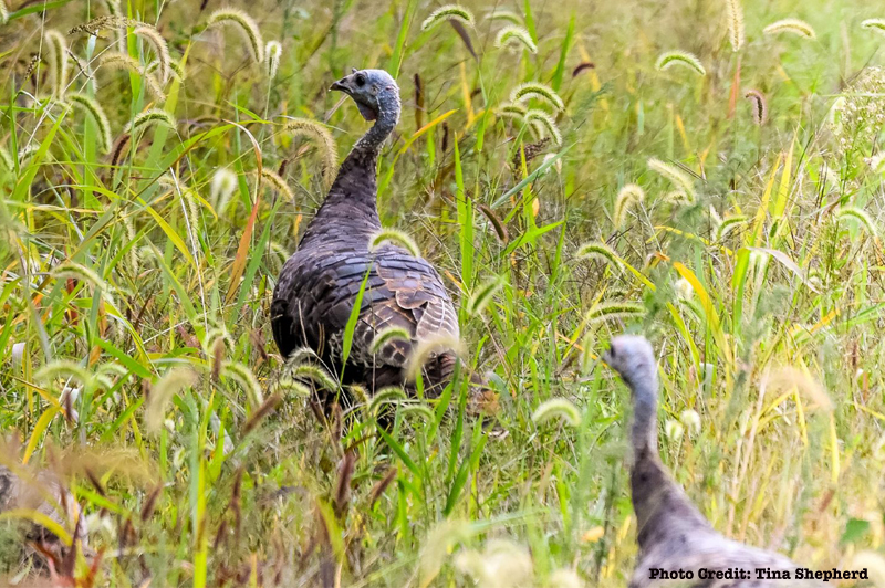
    The NWTF Ohio State Chapter recently allocated $50,000 to support a new wild turkey research study that seeks to address population declines in the state.

    With increasing concerns over population declines in Ohio, the Ohio Department of Natural Resources and Ohio State University are conducting the first broad-scale study of hen survival in the state in almost two decades. Findings will help researchers and wildlife managers understand how survival rates, harvest rates and reproduction have changed in the last 17 years and what factors may be causing those changes.

    In the early 2000s, researchers determined May 1 to be the median date for which hens begin incubating; however, it’s clear today that incubation start dates vary in different regions of the state. Changing weather and habitat conditions, too, may be impacting the initiation of nest incubation from the median date established in the early 2000s.

    “There are growing concerns about the potential impacts regarding the timing of the removal of males during the hunting season, and therefore it is important to know as precisely as possible when hens begin incubating nests,” said Ryan Boyer, NWTF district biologist for Michigan, Indiana and Ohio. “In many cases, state agencies set their season open dates to coincide closely with the median date for nest incubation initiation, allowing time for hens to be bred and for nesting to begin. Ensuring that season start dates align with nesting chronology greatly reduces the chance of negatively impacting populations by removing males too early.

    “Just like the world around us, wild turkey ecology is dynamic. We are proud to partner with the ODNR and Ohio State University to provide support for this research project and continue to ensure the best-available science is being used in informing management and regulatory decisions.”

    Mark Wiley, ODNR game bird biologist, notes that it is not just timing that can have an effect nesting success, but also changes in habitat.

    “Afforestation (establishment of a forest or stand of trees in an area where there was no previous tree cover) and forest maturation affect habitat quality, which in turn can affect nesting productivity and hen survival,” he said. “A more thorough understanding of hen demographics in relation to changing habitat conditions will improve our ability to successfully manage a dynamic wild turkey population.”

    Beginning in early January and through March, ODNR staff will capture birds using rocket nets. Once captured, researchers and ODNR staff will quickly work to attach leg bands as well as GPS transmitters. The information from the transmitters will be invaluable to researchers.

    “Researchers from OSU will download and monitor turkey location and activity data two to three times per week,” Wiley said. “They will use turkey location and activity data to detect nesting activity, movements and mortality events.”

    The researchers will confirm nesting activity by locating the birds on the ground, and after the incubation period, the team will be able to determine nest fate, hatching rates and causes of nest failure, if it fails.

    Three weeks after a successful hatch, the research team will locate and count the number of poults with each hen. They will also establish an annual survival rate of hens from transmitter data. That data will allow researchers to determine the sources of mortality and investigate the seasonal movements of hens.

    Results of the study will be shared with nearby states that are conducting similar wild turkey research projects, including New Jersey, Pennsylvania and Maryland, and data will be aggregated to provide a larger representation of how climate and habitat changes impact nesting on a landscape scale.

    “The research project is important to all hunters, experienced or new,” said Bill Sulicks, NWTF Ohio State Chapter president. “We are all eager to see the turkey population begin to thrive again as in earlier years.  We believe this study can guide us, in a way, to approach the recent decline, and so in saying this: ‘Once you are aware of a problem, you need to understand how it works, before you can fix it.’”

    Field work, including turkey trapping and telemetry monitoring, will occur throughout this year and 2024 and may continue into 2025. The final project report, thesis and scientific manuscript will be available at the end of the project in 2025.

    About the National Wild Turkey Federation

    Since 1973, the National Wild Turkey Federation has invested over half a billion dollars into wildlife conservation and has conserved or enhanced over 22 million acres of critical wildlife habitat. The organization continues to drive wildlife conservation, forest resiliency and robust recreational opportunities throughout the U.S. by working across boundaries on a landscape scale.

    2023 is the NWTF’s 50th anniversary and an opportunity to propel the organization’s mission into the future while honoring its rich history. For its 50th anniversary, the NWTF has set six ambitious goals: positively impact 1 million acres of wildlife habitat; raise $500,000 for wild turkey research; increase membership to 250,000 members; dedicate $1 million to education and outreach programs; raise $5 million to invest in technology and NWTF’s people; and raise $5 million to build toward a $50 million endowment for the future. Learn how you can help us reach these lofty goals.

  • Come along for a unique aerial tour across Ohio

    Come along for a unique aerial tour across Ohio

    Come along for a unique aerial tour across Ohio featuring some of the beautiful locations managed by the Ohio Division of Natural Resources. You might discover a weekend or day trip right here in Ohio.

  • Loveland Bike Trail bridge in Historic Downtown Loveland to close for 3 days

    Loveland Bike Trail bridge in Historic Downtown Loveland to close for 3 days

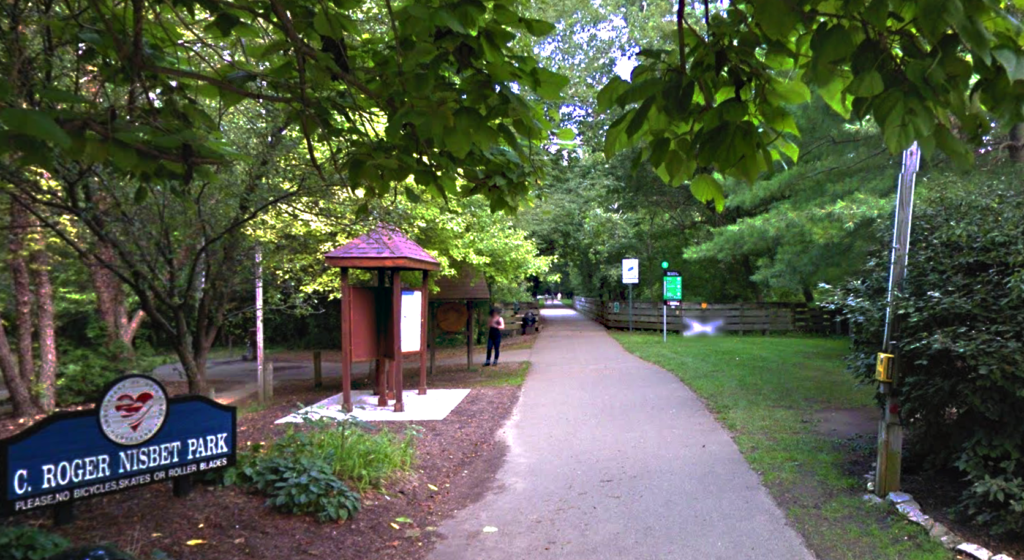
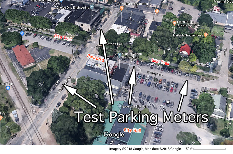
    Loveland, Ohio – The Ohio Department of Natural Resources has notified City Hall that the Loveland Bike Trail bridge over O’Bannon Creek, near Nisbet Park, will be closed for three days to conduct a feasibility study and soil borings for future repairs.

    The closure is expected during the week of July 27th.

  • Repairs ahead to Nisbet Park restrooms

    Repairs ahead to Nisbet Park restrooms

    Loveland, Ohio – The City was notified in November that its NatureWorks Grant application was approved by the Ohio Department of Natural Resources (ODNR). The grant amount of $18,294 will

    include a local match of $6,098 to complete repairs to the Nisbet Park restrooms. Repairs include roofing, exterior doors, interior/exterior painting, skylights, and lighting. Also included in the project, is a new ADA compliant drinking fountain with bottle filler.

    Nisbet Park is the heart of what local folks have always called the  “Loveland Bike Trail”, and where the Little Miami Scenic Trail was first paved in 1989. Construction of the first paved miles of the Little Miami Scenic Trail began in Loveland and headed north into Warren County to Morrow. For decades the park and its related parking were the most accommodating spot on, and perhaps still the most popular place to access the trail. The trail runs parral to the Little Miami River along much of its length, a State and National Scenic and Wild River.

    Dedicated on December 20, 1991, the Little Miami Scenic Trail runs from Spring Valley in Greene County to the limits of Terrace Park. The Little Miami Scenic Trail is the third-longest paved trail in the United States, running 78.1 miles (125.7 km) through five southwestern counties. Most of the trail runs along the banks of the Little Miami River, in a dedicated, car-free corridor known as Little Miami State Park. The Little Miami Scenic Trail is signposted as State Bike Route 1 south of Xenia and State Bike Route 3 throughout. It is the backbone of a nearly continuous network of paved multi-use trails, centered on the Miami Valley area, that stretches 330 miles (530 km) and connects the Cincinnati, Dayton, and Columbus metropolitan areas. The Little Miami trail is an incrementally growing section of the Buckeye Trail and North Country National Scenic Trail, while the trail south of Xenia also forms the southern leg of the Ohio to Erie Trail. Together with the Ohio Department of Natural Resources, the local governments of Xenia and Yellow Springs purchased land along the abandoned railroad from 1973 to 1983. In 1979, the land became an Ohio State Park. The Loveland Bike Trail was added to the state park in 1984*

    *From Wikipedia, the free encyclopedia


  • “Test” parking meters to be installed in Historic Downtown in pilot project

    “Test” parking meters to be installed in Historic Downtown in pilot project

    If the pilot project proves successful 110 total meters might be installed

    by David Miller,

    Loveland, Ohio – City Manager Dave Kennedy is awaiting approval from the Ohio Department of Natural Resources (ODNR) before installing 39 test parking meters in Historic Downtown. The property where 26 of the meters are to be located is street parking along Railroad Avenue and the poles would be in the “right of way” controlled by ODNR along the Loveland Bike Trail.

    IPS Single Space Meter

    The test meters would be on West Loveland Avenue, and Railroad Avenue from West Loveland to Harrison Avenue. Kennedy said he is waiting on a person from ODNR to return from vacation so they can continue their discussion of the right of way issue.

    Kennedy is working exclusively with The IPS Group in a test of their meters before possibly installing more of the metered parking. When asked if he has an idea what the parking rate will be he said, “Not yet. I need to clear up right of way with ODNR for the pilot program.”

    Kennedy said, “I should add that we hope that the pilot program helps us establish a reasonable parking rate. It is important that the rates of the parking meter find a balance between not having a negative impact on parking within the downtown district while also allowing the meters to effectively manage parking.”

    Private interests have begun restricting public parking in private lots in Historic Downtown.

    In a June 26 memo to the Mayor and Council he said, “Having reviewed the products of multiple meter companies, the city has decided to work exclusively with the IPS Group due to their advanced technology, ease of enforcement, foolproof collections, and varying designs.” Kennedy also said, in the memo, “The IPS Group are leaders in the parking meter and kiosk field. The IPS meters are equipped with advanced technology, including mobile applications for the users, advanced enforcement, computerized reporting, and fail-safe collections.” There has been no discussion of penalties for violations.

    Loveland City Manager Dave Kennedy is exploring using parking meters in the Historic Downtown.       (File Photo)

    “The initial installation is only a pilot program at no cost to the city to determine operational, collections, and enforcement needs,” said Kennedy.

    It is a goal of Council to increase parking turnover in the Historic District and discourage long-term parking in prime retail spots by users of the Loveland Bike Trail. The City would rather bike trail users park in the Linda J. Cox Trailside Parking Area on East Broadway.

    Kennedy said that IPS meters are the industry leaders due to multiple features, most notably applications which allow the users many ways to pay, including through their mobile devices.

    To discourage long-term parking in the Historic District parking is already being regulated by parking limits such as these next to Nisbet Park along the Loveland Bike Trail.

    The meters will be solar powered and managed by the City through a wireless networked data management system. The City Manager said the meters will be easy to maintain and displays a clear violation indication for enforcement. He said the system includes a “failsafe” collection system.

    The design of the meters would include one pole for each two meters, which Kennedy said would reduce obstructions along city curbs and would be black in color to match other city sidewalk components.

    If the pilot program is successful, Kennedy has presented a plan where there might be anywhere from 27-110 permanent meters and an estimated cost between $32,599 and $124,125.