
Promoted Post www.runlikealovelandtiger.com
![]()
News and Events from the Loveland, Ohio Area
Without fear or favor
Since 2004

by David Miller
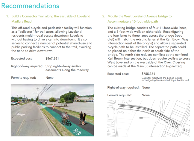
Loveland, Ohio – The City commissioned a study of how to alleviate parking congestion yet bring more customers into Historic Downtown by developing a new crossing over the Little Miami River. The report was released last Wednesday. The recommendation is to create “parking pods” in existing commercial and school parking lots or create new parking lots on existing City owned land in the Loveland Madeira Road business corridor and in the West Loveland Historic District. A new ten-foot shared pathways for pedestrians and bicycles along Loveland Madeira, West Loveland Avenue, and possibly Main Street would bring the customers into the Historic District via the existing roadway of the Col. Thomas Paxton Bridge.
Talk of a new bridge over the State and National Little Miami Scenic River or expanding the existing bridge over the river have been abandoned in favor of using a shared lane for pedestrians and bicycles on the existing roadway over the bridge.
While a stand-alone bridge, a modification to the existing bridge to create a cantilever type path were both examined, the most feasible and cost-effective crossing entails the modification of the existing lanes of traffic of the bridge to accommodate an expansion of the existing sidewalk.
 Project Goals
• Develop a safe, feasible crossing over the Little Miami River • Reduce downtown traffic congestion by encouraging riders to park and ride into downtown
The preferred option according to a recommendation to City Council by City Manager Dave Kennedy is to modify the Col. Thomas Paxton Bridge to accommodate a 10 ft. wide separated path with three vehicle lanes across the bridge. The “collector pathway” is expected to encourage Loveland Bike Trail users to “park and walk or ride” into the Historic Downtown District.
The Loveland Collector Trail will be a new, shared use, grade-separated facility connecting the Loveland Madeira Business Corridor to the Historic Downtown District. The intent of this facility is to provide visible, shared parking opportunities at strategic locations west of the river, along Loveland Madeira Rd, where Little Miami Scenic Trail users – or general visitors to Downtown Loveland – can park their vehicle and follow an easily-navigable shared-use trail along Loveland Madeira Rd, across the Little Miami Scenic River and into the Historic Downtown District to the Little Miami Scenic Trail trailhead.
The eastern terminus of the proposed Loveland Connector Trail will begin at the proposed Deer Ridge II development (1401 Loveland Madeira Rd). The shared-use path will continue along Loveland Madeira Rd to W Loveland Rd, where users will turn right onto W Loveland Ave and cross the Little Miami Scenic River on the existing W Loveland Ave bridge into downtown Loveland.
Similar to the preferred alignment, the shared-use path will continue along Loveland Madeira Rd to the south of Main Street where the City owns a vacant development parcel (referred to as the Chestnut St. Development) between Loveland Maderia Rd and the river. Users can turn right onto one of the three access points into the Chestnut St. development. From there they can either head north through the future development or the existing residential streets to access a river crossing.
“Next step is to seek funding for construction.” – City Manager Dave Kennedy
Kennedy is confident he will find 80% of the $1,623,000 cost from the Federal Government. The city was able to secure grant funding ($19,900) from the Hamilton County Planning and Development Department to conduct the feasibility study. At the council meeting, he said, “Next step is to seek funding for construction. We are still digesting it… looking for the funding.” He said councilman Ted Phelps is reaching out to the Ohio, Kentucky, Indiana Regional Council of Governments (OKI) for funding.
Also during the Council discussion, Phelps who is spearheading the project, inherited from former councilman Brent Zuck, said about the Loveland Connector Trail, “This serves two larger, important goals and it’s a big step towards getting those goals realized. Number one is to reduce traffic in downtown Loveland. Second thing it does… I think it’s an economic shot in the arm for the Loveland Madeira corridor which I think will have positive repercussions.”
Phelps said that people who are using the bike trail are using too many of the downtown parking spots and using them for too long a period of time. “This is going to give them another place to get on the trail, better parking, easier on and off.”
“In delivering it (the study) to Bob Koehler at last week at the regular OKI meeting, he was very positive in terms of its reception,” said Phelps. Koehler is Deputy Executive Director/Transportation Manager at OKI.
Phelps said, “We will be moving forward on this and I think it will be another great feather in the cap of Loveland when it’s realized.”
“We still need people to weigh in on it,” Phelps said. “We will be moving forward on this and I think it will be another great feather in the cap of Loveland when it’s realized.” He suggested the plan be put on the City’s website.
The study does not contain any data on potential number of users, nor potential customers to Loveland Madeira Road businesses. The study also does not address any repercussions on the residential neighborhood of Main Street or the Business/Residential neighborhood on West Loveland Avenue.
There has been no recommendation to forward the plan to the Planing and Zoning Commission, Tree and Environment Committee, Beautification Committee or Safety Service & Street Improvement Committee for review. No public hearings are scheduled.
You can DOWNLOAD the full report HERE: Loveland Collector Trail Feasibility Study