Loveland, Ohio – The annual Independence Day parade will depart the campus of the Loveland Primary/Elementary schools at 7 PM heading up Loveland Madeira Road to the West Loveland Historic District, crossing over the State and National Scenic Little Miami River, and ending in Historic Downtown.
There will be a festival in the Historic District starting at 4 PM.
Fireworks will be launched over the river beginning at 10 PM
Loveland, Ohio – East Kemper Road will be closed for two (2) hours on Thursday to accommodate concrete trucks at the project site where road repairs are being made. The time frame will be from Noon to 2 PM according to City Manager Dave Kennedy.
Detour signs will be installed to re-direct traffic.
Due to the need to make emergency road repairs along near 278 East Kemper Road and the corporation limits, the roadway was reduced to one lane on Monday, June 25th. The complete construction job will last approximately two weeks.
The roadway has failed because of erosion on the bank of the Little Miami River.
Several sites in Ohio are poised to join the extremely prestigious UNESCO World Heritage List, with more than 1000 other properties around the globe, including the Pyramids of Giza, the Great Wall of China, Australia’s Great Barrier Reef, and Stonehenge. World Heritage inscription is based on stringent criteria, and signifies outstanding universal value to humanity. Making the list helps ensure a site’s permanent preservation, enhanced understanding, deeper appreciation, and increased tourism.
Oregonia, Ohio, Warren County, Ohio– The Ohio House and Senate passed identical resolutions supporting a United Nations Educational, Scientific, and Cultural Organization (UNESCO) World Heritage Site nomination for the Hopewell Ceremonial Earthworks at Ft. Ancient.
Also included in the nomination are the Hopewell Ceremonial Earthworks, located in, Ross County, and Licking County They are described as being the epicenter of a vibrant American Indian culture that lived in Ohio approximately 2,000 years ago.
These sites were ceremonial and social centers, characterized by enormous earthwork constructions that feature precise geometric shapes, standard units of measure, accurate alignments to the rising and setting of the sun and moon, and deposits of artifacts of exceptional artistic merit crafted from exotic raw materials obtained from as far away as the coast of the Atlantic Ocean and the Rocky Mountains.
Ft. Ancient is a short drive up I-71 or U.S. 22 along the eastern shore of the Little Miami River. The site and museum are at 6123 St. Rt. 350 in Oregonia. 513–932–4421 or 1–800–283–8904.
Riverside Park American Legion Ground and Riverside Park, 450 Victor Stier Dr, Milford, Ohio 45150
The City of Milford will be celebrating with Frontier Days Inc. the 56th Annual Frontier Days Parade and Festival May 31 through June 3. The festival is located along the banks of the Little Miami River.
The Frontier Days Committee is excited to bring back Milford’s hometown parade and festival that has been taking place for 56 years.This is one of Clermont County’s oldest parades.
This year’s Grand Marshal is Milford Head Football Coach, Tom Grippa. This year’s parade theme is “Fly Like An Eagle”.The Parade begins at 746 Lila Ave and ends at Main and Locust Street in Historic Milford. Cash Prizes for Float entries. Best Themed and Judges Choice.
The Festival will have Live Music each night from 8-12 PM, featuring The Mondays on Thursday, Nick Netherton on Friday, and Naked Karate Girls on Saturday.
The ever popular, Frontier Days Annual Frog Jumping Contest, will take Saturday at 1:30 PM sponsored by All About Kids, Wards Corner. Cash prizes for 1st, 2nd, and 3rd place.And returning this year will be the Decorated Bike Parade on Sunday. Prizes will be awarded.
EDITOR’S NOTE: In reaction to this editorial, City Council voted on Tuesday, April 24 to have a public hearing on this proposal during the City Council meeting of May 9.
It’s past time City Hall start a dialogue with those most affected
by David Miller, Publisher
Come take a walk with me while I tell you a story
It’s just my opinion, but I believe City Hall should start talking to people about this before it gets so far along people will need 1.6 million dollars worth of arguments against it. Once City Hall gets the funding for what they will describe as “Free Money” it will be extremely hard to turn council members to “No” votes. Residents should be given a fighting chance.
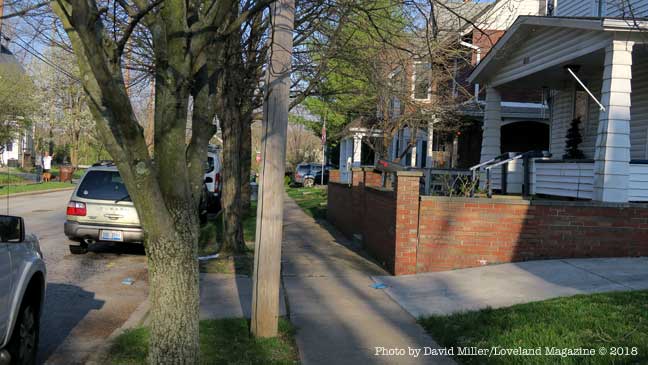
As the equivalent of a one-lane asphalt road that will cozy within feet of the front doors of homes and businesses in the West Loveland Historic District and along Loveland Madeira Road, and City Hall moves closer to securing funding, property, and homeowners have yet been asked their opinion. Almost all do not yet know the proposal has already been partially funded by Hamilton County and the Ohio, Kentucky, Indiana Council of Governments has committed their resources to finding 80 percent of the $1,623,000 and growing price tag for construction.
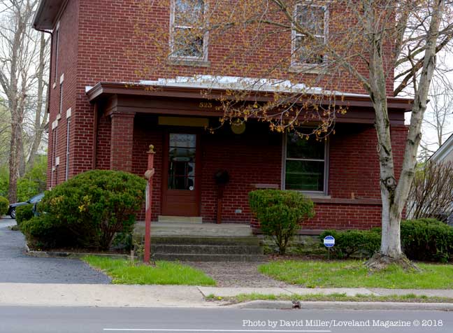
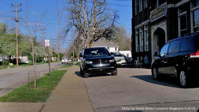
This is a view of the North side of West Loveland Avenue where construction of a 12′ wide swath of asphalt would require the removal of the front porch of this business. The entry to the basement of this business is through the porch floor.
Some front porches would have to be removed to accommodate the 12’ wide asphalt bicycle road. The road will be reduced to 10’ wide only where construction proves difficult.
As the City Hall proposal gets yet more expensive and closer to fruition there is still no initiative from the Council table to ask the thoughts and suggestions of citizens, home-owners, affected businesses, property owners, or pertinent City Commissions and Committees.
As the City Hall proposal gets yet more expensive and closer to fruition there is still no initiative from the Council table to ask the thoughts and suggestions of citizens, home-owners, affected businesses, property owners, or pertinent City Commissions and Committees.
One property and business owner along the proposed route wrote to City Hall. Paul Elliott said, “I am under the impression that such a proposal ‘has legs’, and city officials are even seeking funding sources. First, as a taxpaying resident and longtime business/property owner on West Loveland Avenue, I am disappointed that no city official has approached either the public in general nor us property owners who may be affected by such a bike corridor.”
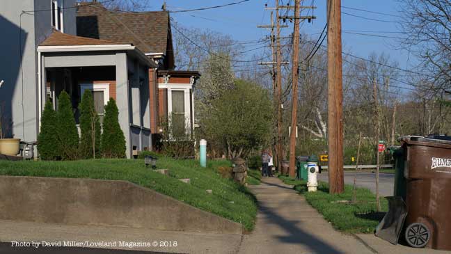
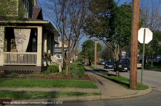
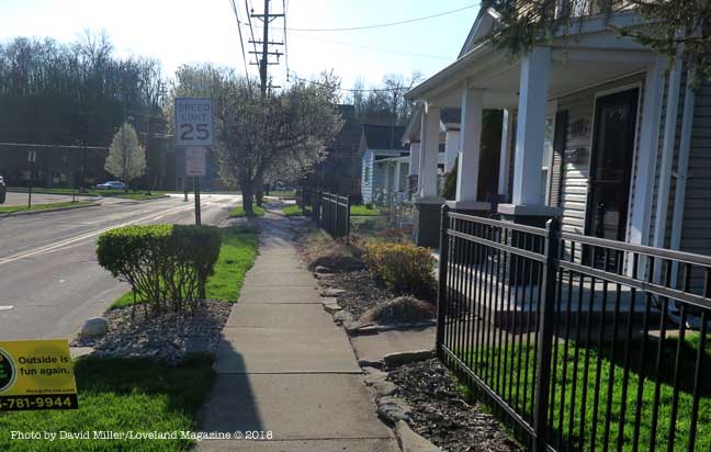
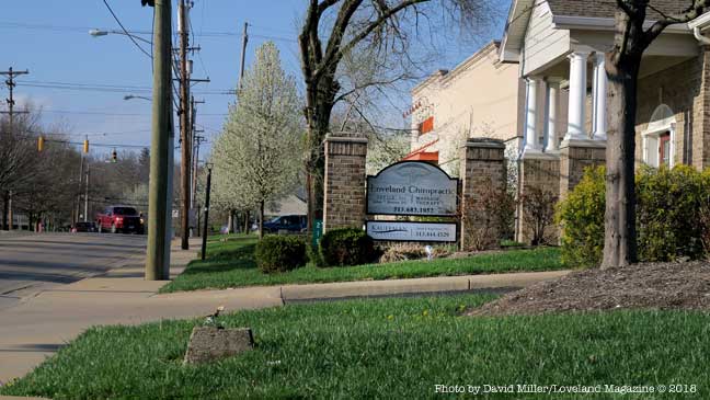
The project, called the Loveland Connector Trail, will be approximately 1.4 miles long and will begin at the Deer Ridge II Apartments being built next to New Hope Baptist Church. It will continue along Loveland Madeira Road to Main Street, to the southern part of Wall Street, then to West Loveland Avenue, crossing over the Little Miami River at the Col. Paxton Bridge ending in Historic Downtown.
“I am disappointed that no city official has approached either the public in general nor us property owners who may be affected by such a bike corridor.” – Resident and affected business owner, Paul Elliott.
The goal and impetus for the project are to reduce congested parking in the Downtown Historic District by encouraging Loveland Bike Trail users to park somewhere along the new bike road and ride their bikes into Historic Downtown.
City Manager, Dave Kennedy announced in February that he was confident he will find 80% of the $1,623,000 cost from the Federal Government. He has since announced changes that will raise the price tag an undetermined amount.
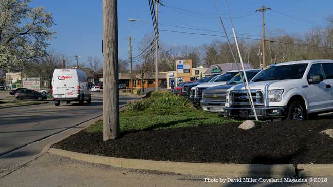
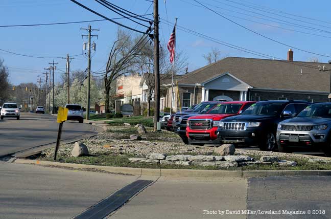
A view of an automobile dealership that has softened their business frontage. Something will have to give way for the proposed 12′ asphalt bike road.
The study does not contain any data on the potential number of users, nor potential customers to Loveland Madeira Road businesses. The study also does not address any repercussions on the residential neighborhood of Main Street or the Business/Residential neighborhood on West Loveland Avenue. For instance, it does not address future maintenance or whether property owners will be responsible for snow and ice removal on a path that replaces their current sidewalks. It’s right to ask when residents are left without sidewalks, “When will the bike road be cleared of snow? Who will do it, with what type of equipment, and when will it happen?”
A close look at what is described as a “Detailed Cost Estimate” appears to be grossly underestimated in terms of things that are absent consideration such as acquiring private property, relocating business signs, and replacing private parking,
Light colored 4′ tree-shaded concrete sidewalks where children can walk without shoes, and people walk their dogs will be replaced with a 12’ barren swath of black, heat-absorbing asphalt the width of a one-lane road just feet from homes.
Light colored 4′ tree-shaded concrete sidewalks where children can walk without shoes, and people walk their dogs will be replaced with a 12’ barren swath of black, heat-absorbing asphalt the width of a one-lane road just feet from homes where owners will pay higher air-conditioning costs.
There has been no recommendation to forward the proposal to the Planning and Zoning Commission, Tree and Environment Committee, Beautification Committee, or Safety Service & Street Improvement Committee for review. No public hearings are scheduled. None have been suggested.
Phelps and City Manager Dave Kennedy have attended workshop/training on a Federal grant program along with a meeting with OKI officials to discuss the city’s project in more detail. While the updated cost estimate is being secured, the grant application is being reviewed and various needed documents are prepared. They plan to ask City Council in May to move forward seeking funding.
Phelps said that people who are using the bike trail are using too many of the downtown parking spots and using them for too long a period of time. “This is going to give them another place to get on the trail, better parking, easier on and off.” He believes the bike road will bring in new customers to Loveland Madeira Road businesses when they park nearby but head into Historic Downtown. The study does not contain any data on the potential number of users, nor potential customers to Loveland Madeira Road businesses. The study also does not address any potential negative repercussions on the residential neighborhood of Main Street or the Business/Residential neighborhood on West Loveland Avenue.
Some “Progressives” may love the idea, some may like it but believe it ill-considered given the impact on individuals who live or have invested in the impacted area. Some money conservatives may believe it an economic boon to both the Historic District and Loveland Madeira Road. Some money crunchers may ask, where is the cost-benefit analysis and just how many people will actually use it and spend money along Loveland Madeira Road. Some may ask if all costs factors have been included in the early estimate and if the price tag goes north after a grant is awarded – who will get stuck.
Elliott said his email to City Hall, that included the City Manager, Mayor and Council, the Planning and Zoning Commission, the Recreation Commission, and the Streets and Public Safety Committee was his attempt to open a dialogue between the decision makers, and those “of us” who will be financially and personally affected.
Resident and business owner Paul Elliott bought this business building on West Loveland Avenue in 1997. He has asked City Hall how the proposed connector path will affect the front yard of his property.This is a view of business and residential properties on the South side of West Loveland Avenue. Although the proposal isn’t clear, presumably this 4′ concrete sidewalk will be replaced by a 12′ wide swath of asphalt, equivalent to a one-lane road. These street trees will with be cut down or have their roots severely damaged by the excavation. It is not clear whether the grassy strip will remain.
Another view of the beauty salon on the North side of West Loveland Avenue where construction of a 12′ wide swath of asphalt would require the removal of the front porch of this business. The entry to the basement of this business is through the porch floor.If the 12′ wide bike road wraps around this building this sign and landscaping will have to go. The sign may need to be replaced with two signs to satisfy the business owner, yet there is no apparent budget item for moving or replacing business signs in the proposal.Depending whether the 12′ bike road goes down this side of Main Street, these street trees may be removed. These utility poles if moved to the left would might result in fatal topping of the trees. If the poles remain in place it puts the asphalt even closer to the house. If the road goes on top of the tree roots the trees will shortly die. The owners will pay higher air-conditioning cost without their shade trees. If the trees die because of the location of the bike road, the home owner will then be required to pay to have the tree removed. Will the homeowner’s brick wall survive the project?This is another problem area on Main Street where homeowners will lose a good portion of their already small front yard.The 12′ bike road could cut across the front yard of this Main Street home taking out a tree and landscaping.Another front porch, this one on Main Street may stand in the way of the 12′ wide asphalt bike road or end up only inches away.If the 12′ wide asphalt bike road goes down this side of Main Street it will leave the Artists Studios on Main without street trees and much needed parking.The landscaping, street trees, utility polls, and sign at this business on Loveland Madeira Road appear to be in the path of the 12′ wide bike road.This landscaping area that softens the appearance of this automobile dealership on Loveland Madeira Road will be replaced with a 12″ asphalt bike road.This is more of the landscaping along Loveland Madeira Road that will be removed (or most of the parking lot) to make room for a 12′ asphalt bike road.
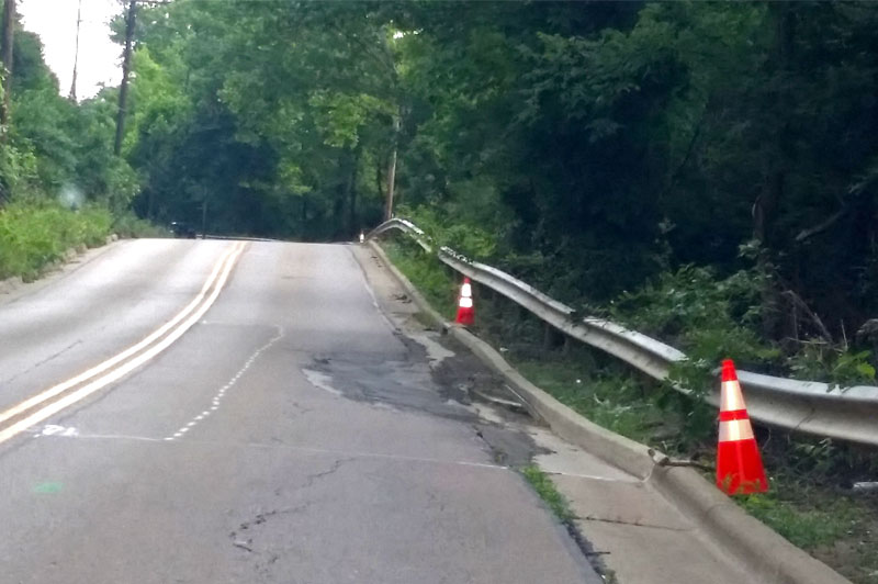
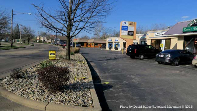
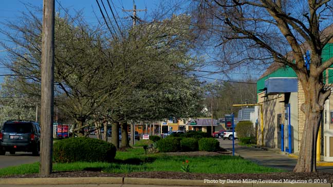
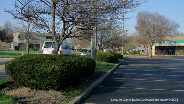
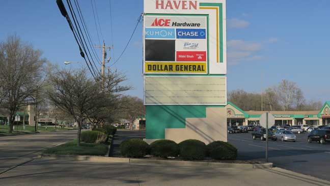
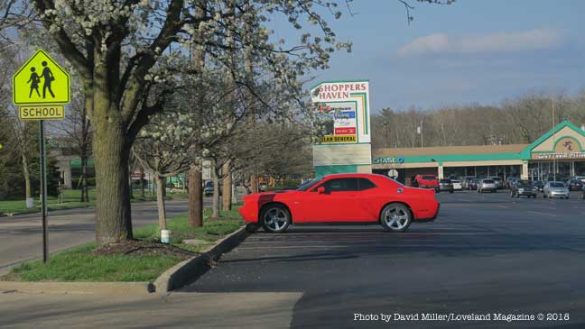
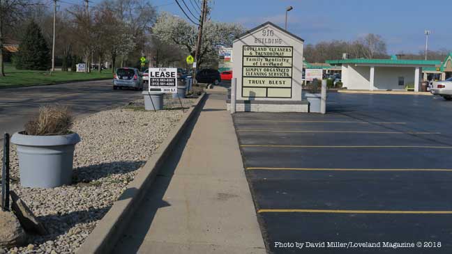
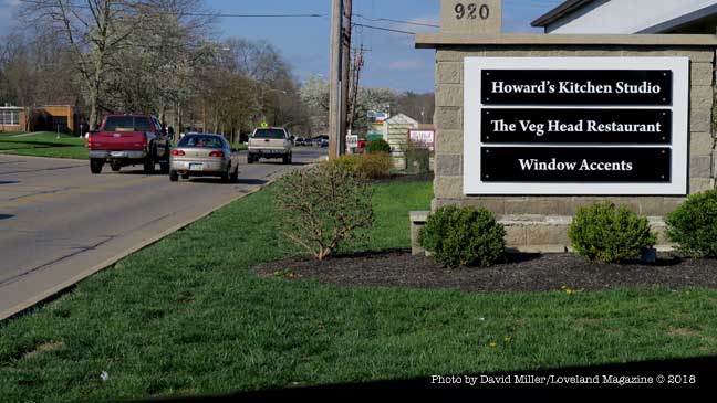
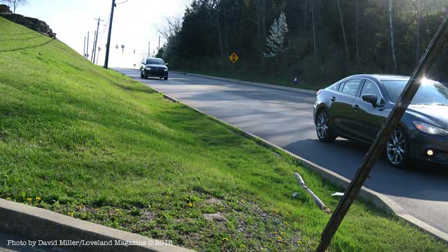
This is the only green space at the Chase Bank on Loveland Madeira Road. There will be a 12′ asphalt bike road running down the middle of it.If a proposed 12′ wide asphalt bike road goes past Shoppers Haven shopping center these street trees may be removed, utility lines moved, parking spaces removed, or all three. Private property may have to be acquired through “willing seller – willing buyer” agreements or “taking” by eminent domain and associated legal costs. In the end, these parking spaces used by local businesses and the schools may be eliminated for the prospect of freeing up parking spaces a mile away in Historic Downtown.There does not appear to be a budget item for moving this business sign out of the path of the proposed 12′ wide asphalt bike road, nor is there any discussion of whether the owner and the businesses would want their sign moved further away from the visibility of automobiles on Loveland Madeira Road.If a proposed 12′ wide asphalt bike road goes past Shoppers Haven shopping center these street trees may be removed, utility lines moved, parking spaces removed, or all three. Private property may have to be acquired through “willing seller – willing buyer” agreements or “taking” by eminent domain and associated legal costs. In the end, these parking spaces used by local businesses and the schools may be eliminated for the prospect of freeing up parking spaces one mile away in Historic Downtown.Will the landscaping and street buffer, the business sign and the parking at the 910 Building be sacrificed to free up an un-estimated number of parking spaces for the businesses one mile away in Historic Downtown?Another Loveland Madeira Road business sign in the way of a proposed 12′ asphalt bike road. Is this sign still going to have the same visibility if it is relocated? Is there enough room to just push it closer to the building or will it need to be re-engineered, and reconstructed smaller?This is the hillside in front of New Hope Baptist Church where City Hall wants to build a 12′ wide asphalt bike road. Its there money in the estimate of cost to build a retaining wall or will the hill just get steeper?This is Loveland Madeira Road looking North from New Hope Baptist Church toward Kroger. The guard rail protects motorists from a steep immediate drop into a very deep ravine. The 350′ long stretch quickly drops 50′ below the grade of the road. It is not clear if the budget estimate has taken into consideration the expense of building a 12′ wide bike road at the edge of this ravine.
Loveland, Ohio – East Kemper Road near the 10098 block (Northeast of Victor Avenue) is currently closed to traffic because of rising waters from the Little Miami River.
Karl Brown Way and E. Broadway in Historic Downtown are currently open, however will certainly close because of the rapidly rising water.
The National Weather Service in Wilmington has issued a “Flood Warning” that is in effect from April 3, 1:47 PM EDT until April 4, 4:15 PM EDT.
Today
Showers and thunderstorms likely, mainly after 5pm. Some of the storms could be severe. Cloudy, with a high near 71. South wind 13 to 18 mph, with gusts as high as 34 mph. Chance of precipitation is 70%. New rainfall amounts between a quarter and half of an inch possible.
Tonight
Showers and thunderstorms before 1am, then a chance of showers. Some of the storms could be severe. Low around 38. Breezy, with a south wind 17 to 20 mph becoming west after midnight. Winds could gust as high as 32 mph. Chance of precipitation is 90%. New rainfall amounts between a half and three quarters of an inch possible.
The Little Miami is expected to reach near “Moderate Flood Stage” at midnight and to reach “Flood Stage” at Kings Mills.
Hazardous Weather Outlook
Hazardous Weather Outlook
National Weather Service Wilmington OH
1031 AM EDT Tue Apr 3 2018

INZ073>075-080-KYZ089>100-OHZ077>082-088-041445-
Ripley-Dearborn-Ohio-Switzerland-Carroll-Gallatin-Boone-Kenton-
Campbell-Owen-Grant-Pendleton-Bracken-Robertson-Mason-Lewis-Hamilton-
Clermont-Brown-Highland-Adams-Pike-Scioto-
1031 AM EDT Tue Apr 3 2018

This Hazardous Weather Outlook is for Southeast Indiana, Northeast
Kentucky, Northern Kentucky, South Central Ohio and Southwest Ohio.

.DAY ONE...Today and Tonight.

Wind gusts to 35 MPH will be possible this afternoon and evening.

Thunderstorms will develop this afternoon and evening, and some
severe storms are expected. These storms will be capable of producing
damaging wind, large hail, tornadoes, and heavy rainfall. The most
likely timing for severe weather will be between 5PM and 2AM.

.DAYS TWO THROUGH SEVEN...Wednesday through Monday.

Wind gusts of 30-35 MPH will be possible early Wednesday morning.
One driver drove his Jeep into the flood waters in the 300 block of East Kemper Road and the occupants had to swim to safety. The automobile remained almost completely submerged overnight and the driver was cited by the Loveland Police because he ignored “Road Closed” signs.
KASICH ISSUES EMERGENCY DECLARATION TO SUPPORT 17 COUNTIES IMPACTED BY FLOODING ALONG OHIO RIVER
Loveland, Ohio – By 7:30 AM the Little Miami River had already crested overnight and begun falling by about 2 feet. Minor flooding was observed in low-lying areas. Cones Road, East Kemper Road, and Karl Brown/East Broadway roads remain closed to traffic.
These photos were taken between 7:30 and 8:30 AM Sunday morning.
Along East Kemper Road.
Along East Kemper Road.
One driver drove his Jeep into the flood waters in the 300 block of East Kemper Road and the occupants had to swim to safety. The automobile remained almost completely submerged overnight and the driver was cited by the Loveland Police because he ignored “Road Closed” signs.
Along East Kemper Road.
Along East Kemper Road.
Photo taken on Lyons Road.
The Linda Cox Trailside Parking lot.
East Broadway Street and Loveland Canoe and Kayak.
The Linda Cox Trailside Parking lot.
East Broadway Street and Loveland Canoe and Kayak.
East Broadway Street and Loveland Canoe and Kayak.
Taken from Riverside/Kemper looking at East Broadway Street and Loveland Canoe and Kayak.
Along East Kemper Road.
The parking lot at the Fraternal Order of Eagles on Karl Brown Way.
Along Cones Road and the Loveland Bike Trail
Along Cones Road and the Loveland Bike Trail
Photo taken on Lyons Road.
Photo taken at 129 N. Riverside Drive.
Photo taken at 129 N. Riverside Drive.
Photo taken at 129 N. Riverside Drive.
KASICH ISSUES EMERGENCY DECLARATION TO SUPPORT 17 COUNTIES IMPACTED BY FLOODING ALONG OHIO RIVER
Declaration Includes Activating National Guard; With Worsening Conditions Ahead, Additional Counties Will Be Added to Emergency Declaration as Needed
COLUMBUS – Today Gov. John R. Kasich issued an emergency declaration for 17 counties along the Ohio River and in southern Ohio due to dangerous conditions resulting from severe storms and heavy rain. An emergency declaration allows the governor to use state resources, including activating the National Guard, to help local officials keep Ohioans safe.
“Ohioans do a good job of looking out for each other and we’re doing it again now also. Teams at the local level are hard at work and state teams have been coordinating with them and supporting them over the past week. As the weather and flooding is expected to get worse we’re staying ahead of things by taking our readiness up to the next level and declaring an emergency where we expect the worst conditions. We’ll quickly add to those areas as it’s needed. I urge people to stay safe by staying informed, not taking any chances and checking in on your neighbors, especially seniors and families with young kids. Call your local city, county or Red Cross if there’s anyone who needs help. We’ll get through this as we always do, by working together,” said Kasich.
So far, Ohio storm and flood preparation efforts include deploying National Guard troops in response to local requests to help install floodgates along floodwalls. Other efforts include:
Providing water pumps to Scioto and Lawrence counties
Holding coordination calls with National Weather Service and state and local response partners
Installing flood gates in the City of Portsmouth
Providing situation awareness reports to federal, state and local partners
The Little Miami River went above flood stage in Milford at 7:30 PM Friday evening. The National Weather Service reported the river at 17.8 feet. Flood level is 17 feet. The level is virtually the same at the Kings Mills recording station. There is no measuring gague in Loveland.
Detailed Weather Forecast for Loveland from the National Weather Service
Tonight
Showers likely, mainly after 4am. Cloudy, with a low around 47. West wind around 6 mph becoming north after midnight. Chance of precipitation is 60%. New precipitation amounts between a tenth and quarter of an inch possible.
Saturday
Showers, with thunderstorms also possible after 5pm. High near 55. East wind around 8 mph. Chance of precipitation is 90%. New rainfall amounts between a half and three quarters of an inch possible.
Saturday Night
Showers and possibly a thunderstorm. Low around 52. Breezy, with a southeast wind 8 to 13 mph becoming southwest 15 to 20 mph after midnight. Winds could gust as high as 32 mph. Chance of precipitation is 100%. New rainfall amounts between 1 and 2 inches possible.
Sunday
A chance of showers before 7am. Mostly sunny, with a high near 54. West wind 11 to 16 mph, with gusts as high as 26 mph. Chance of precipitation is 30%. New precipitation amounts of less than a tenth of an inch possible.
Sunday Night
Partly cloudy, with a low around 33. West wind 5 to 7 mph becoming calm in the evening.
Monday
Sunny, with a high near 56.
Monday Night
Mostly clear, with a low around 32.
Tuesday
Sunny, with a high near 60.
Tuesday Night
Mostly cloudy, with a low around 43.
Wednesday
A chance of showers after 7am. Mostly cloudy, with a high near 59. Chance of precipitation is 50%.
Wednesday Night
Showers likely. Mostly cloudy, with a low around 47. Chance of precipitation is 60%.
Thursday
Showers likely. Mostly cloudy, with a high near 58. Chance of precipitation is 60%.
Thursday Night
A chance of showers. Mostly cloudy, with a low around 39. Chance of precipitation is 30%.

 campus of the Loveland Primary/Elementary schools at 7 PM heading up Loveland Madeira Road to the West Loveland Historic District, crossing over the State and National Scenic Little Miami River, and ending in Historic Downtown.


 The City of Milford will be celebrating with Frontier Days Inc. the 56th Annual Frontier Days Parade and Festival May 31 through June 3. The festival is located along the banks of the Little Miami River.
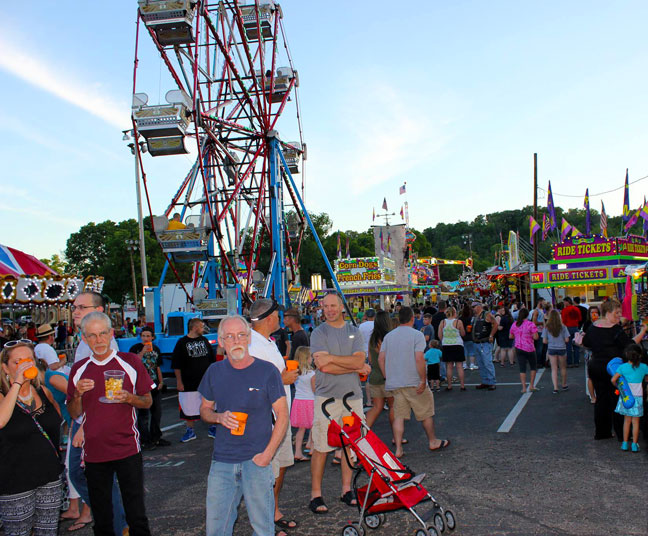 The Frontier Days Committee is excited to bring back Milford’s hometown parade and festival that has been taking place for 56 years.

 by David Miller, Publisher
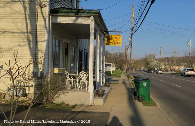

 Affectionately called the “Loveland Bike Trail” it is the Little Miami State Park and it is 70 miles long with connections to well over 100 miles.
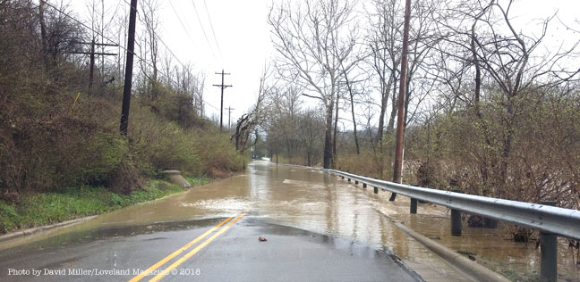

![[Photo Album] Minor flooding closes Cones Road, East Kemper Road, and Karl Brown/East Broadway](https://lovelandmagazine.com/wp-content/uploads/2018/02/Loveland-Flooding-2-25-2018-18.jpg)